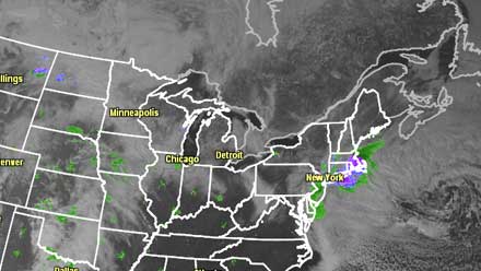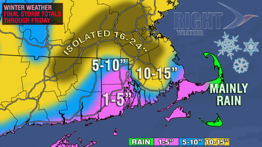
A historic March Nor’easter is finally losing its grip on the weather in Southern New England. The large storm was hundreds of miles away in the Atlantic Ocean, but still managed to deliver very heavy snow, strong winds, and major coastal flooding to Southern New England over a two to three day stretch. Worcester, MA was sitting at 22.8″ as the snow was winding down on Friday afternoon. Since 1892, only one storm after February 25 (March 31-April 1 1997) has produced that much snow in Worcester. A house was lost to the ocean on Plum Island, MA during the high tide on Friday morning. Nantucket had at least 48 consecutive hours of 30+ mph sustained winds with gusts greater than 40 mph.

Rhode Island was spared the worst of it, with 10″ of snow falling in the hardest hit areas. The final snow totals for the storm ranged from an inch or two in parts of Washington and Kent County where a “snow hole” existed for most of the storm to about two feet in a few spots in Central and Eastern MA.

The weather will take a big turn for the better this weekend. Skies will gradually clear Friday night, and the temperature will fall below freezing, so take it slow on the roads. Saturday looks bright, brisk, and cool. The breeze will be 10-20 mph – a far cry from the gusty winds of the last few days. There should be a decent amount of sunshine with highs in the low 40s.
- Event Forecast: St. Pat’s 5k and parade in Providence, RI
- Event Forecast: Celtic 5k in Worcester, MA
The weather will stay quiet on Monday as the wind swings around to the south and the temperature tops out in the mid to upper 40s with increasing late-day clouds. A cold front will bring rain showers on Tuesday. Prior to the showers, the temperature may reach 50° at TF Green Airport for the first time since January 31. The weather will turn cool again late next week, and there are some signs that another storm will bring snow, rain or a mix Thursday night into Friday.


