It took a while for clouds to burn off on Monday, but, once they did, the temperature rose into the upper 40s to low 50s in Southern New England. The high temperature at TF Green was 49, extending the streak to 39 days since the last 50 degree temperature was recorded. It’s quite likely that the temperature will reach 50 on Tuesday, but the mild weather will be accompanied by clouds and, eventually, rain.
11 days into March & already guaranteed that there will not be as many 50°+ days as last year in Providence. 2012: 23 days, 2013: 0. #RIwx
— Right Weather (@RightWeather) March 11, 2013
The temperature will not fall too far Monday night with mostly cloudy skies and some patchy fog developing. Lows Tuesday morning will be in the upper 30s to low 40s. Clouds will be stubborn all day, and fog may be prevalent near the coast with a south-southeast wind ahead of the approaching cold front. There is the chance of a few showers in the morning, with a better chance of rain by mid to late afternoon.
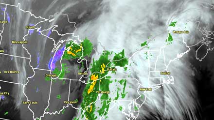
The afternoon commute could be soggy with steady rain possible. It will be breezy near the coast and mild everywhere. There should be 0.5-1 inch of rain, and that combined with melting snow in Central and Southeastern MA may have rivers running high, with the possibility of minor flooding. Of course, most of Rhode Island was in the “snow hole” during the storm late last week, so the threat of any river/stream flooding is much lower. The National Weather Service has issued a Flood Watch for part of Central and Eastern MA.
Rain will end around midnight as the front moves offshore. Colder air will lag behind the front, and the timing looks good for a reasonably mild, sunny Wednesday. There will be a dry westerly breeze with highs in the upper 40s to low 50s under mostly sunny skies. The mild weather will not last for long, with a noticeable chill arriving by late in the workweek. It should stay dry, but gradually get colder, late in the workweek. Highs Friday may struggle to reach the low 40s.
The St. Patrick’s Day weekend may feature a bit of wet and wintry weather. An Alberta Clipper will threaten Southern New England with rain/snow on Saturday. Right now, it looks like the precipitation will be steadiest Saturday afternoon. The track of the storm will determine the precipitation type, and, at this point, we’re favoring chilly rain over snow. The overall cool weather pattern will last into early next week.


