So much for that unseasonably mild start to April. The weather has taken sharply colder turn in Southern New England. One day after reaching the upper 50s to low 60s, the temperature struggled to reach 40° under partly sunny skies. The clouds will clear Tuesday night, and the temperature will fall into the 20s by dawn. The wind will stay between 5-15 mph, and the wind chill will be in the single digits early Wednesday morning. Lows will range from the low 20s inland to the upper 20s near the coast.
Wednesday will feature plenty of sunshine, but it will still be on the cool side, with highs in the low to mid 40s. The wind will be active again, between 15-30 mph during the afternoon. The dry/windy conditions are leading to an elevated fire danger threat in Southern New England. While not quite a Red Flag Warning, there is the potential for fast-spreading brushfires. The following is from the National Weather Service office in Taunton, MA.
...DRY AND WINDY CONDITIONS ARE EXPECTED FOR TOMORROW...

DRY AND WINDY CONDITIONS MAY CAUSE AN ELEVATED FIRE WEATHER
POTENTIAL FOR TOMORROW ACROSS MASSACHUETTS AND RHODE ISLAND.
EXPECT GUSTY WINDS AROUND 30 TO 40 MPH AND RELATIVE HUMIDITIES
DROPPING BETWEEN 20 TO 30 PERCENT. LOCAL FIRE WEATHER OFFICIALS
HAVE ADVISED THAT FINE FUELS...GRASSES AND LEAF LITTER...WILL BE
VERY RECEPTIVE FOR IGNITION. IN FACT ANY FIRE ACROSS UNSHADED FINE
FUELS CAN RAPIDLY SPREAD IN THESE GUSTY CONDITIONS.
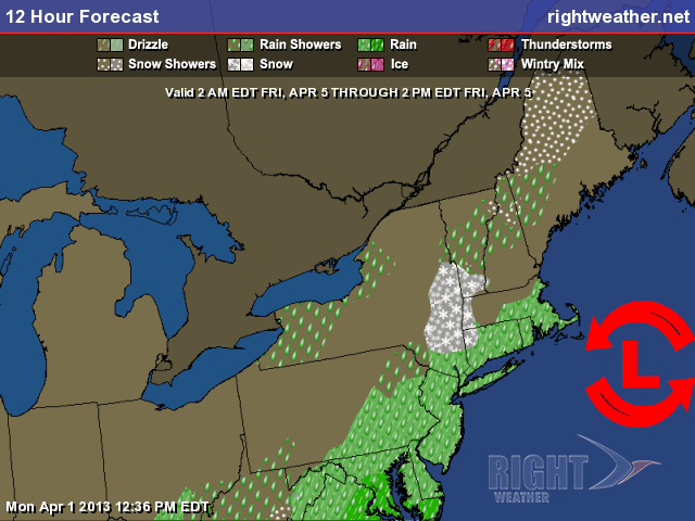
Look for the wind to diminish Wednesday night under clear skies. The temperature will tumble into the 20s again. High pressure will be overhead on Thursday morning, and the wind will come around to the west-southwest as the high pressure system moves off the Mid-Atlantic coast. It will still be a few degrees cooler than normal on Thursday afternoon, but it’ll be milder than Tuesday/Wednesday with highs close to 50. A storm will move from the Gulf of Mexico on Thursday to the Mid-Atlantic coast on Friday. It will likely come close enough to bring some rain to Southern New England. Right now, it looks like the best chance of steady rain is near the coast on Friday afternoon and evening. The track of the storm will determine how far inland the rain reaches. There is the potential for a decent dose of rain in all of RI and SE MA if the storm tracks just a bit closer than currently projected. Highs will be in the 40s with a northeast breeze on Friday. The weekend is shaping up to be decent. Highs will be in the upper 40s to low 50s on Saturday, and low to mid 50s on Sunday. Both days will be partly to mostly sunny.

Rain threat on Friday