Early-spring warm-ups usually don’t have a long shelf life, and that was certainly the case with latest one in Southern New England. The high on Wednesday was in the 60s in most places, but it will not be reaching 60° in the next couple of days. In fact, it may struggle to reach 50° in some spots on Thursday, and Friday may not make it out of the 30s inland!
Showers and t-storms Wednesday evening signified the arrival of the cooler airmass. A northeast wind will keep the temperature in the upper 40s to low 50s on Thursday afternoon. There will be more clouds than the past couple of days, but rain showers should be widely scattered.
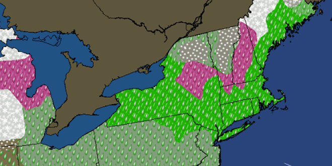
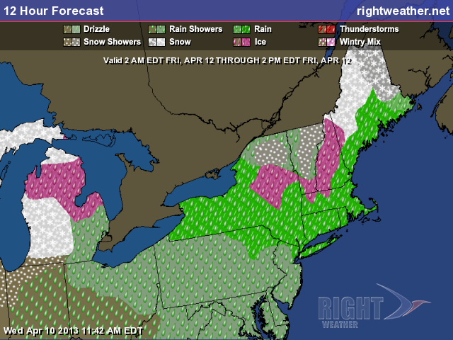
The weather will deteriorate Thursday night into Friday. It will be raw and rainy by Friday morning, and the rain will continue throughout the day. There may even be some mixed precipitation at the onset in the hills of NW RI, NE CT and Worcester County. The temperature will be stuck in the upper 30s to mid 40s with a gusty easterly wind. Overall, it looks like a miserable day, with the potential for about an inch of rain by the time the storm passes.
The good news is the storm will move relatively quickly, and Southern New England is still set up for a decent weekend. Right now, Saturday looks like the warmer of the two days, but only by a few degrees. Highs will be in the mid to upper 50s under partly to mostly sunny skies with a drier westerly wind. Sunday should be partly cloudy with highs int he low to mid 50s.
The weather looks decent early next week. Conditions should be good for the Boston Marathon runners on Monday. The temperature will rise from the 40s into the 50s. A southwesterly (tail wind) breeze will develop during the day. Another warm-up is possible in the middle of the week. It may not be long before the temperature reaches 70 again.
After back to back relatively warm days the average temperature for April is now running about a degree above normal in Providence.
APR-13 FOR PROVIDENCE, RI (62')                     LAT=41.7N LON= 71.4W

                 TEMPERATURE                       PRECIPITATION
          ACTUAL           NORMAL
        HI   LO  AVG     HI   LO  AVG   DEPT     AMNT   SNOW SNCVR   HDD
 1      61   34   48     53   35   44     +4     0.08    0.0    0     17
 2      44   26   35     54   35   44     -9     0.00    0.0    0     30
 3      46   31   39     54   36   45     -6     0.00    0.0    0     26
 4      54   30   42     54   36   45     -3     0.00    0.0    0     23
 5      62   38   50     55   36   46     +4     0.00    0.0    0     15
 6      49   31   40     55   37   46     -6     0.00    0.0    0     25
 7      54   27   41     56   37   46     -5     0.00    0.0    0     24
 8      65   44   55     56   37   47     +8     0.00    0.0    0     10
 9      77   46   62     56   38   47    +15     0.01    0.0    0      3
10      67   46   57     57   38   47    +10     0.39    0.0e   0      8
                  TOTALS FOR PVD
HIGHEST TEMPERATURE   77         TOTAL PRECIP        0.48
LOWEST TEMPERATURE    26         TOTAL SNOWFALL       0.0
AVERAGE TEMPERATURE 46.6         NORMAL PRECIP       4.36
DEPARTURE FROM NORM +0.9         % OF NORMAL PRECIP    11
HEATING DEGREE DAYS  181
NORMAL DEGREE DAYS   479


