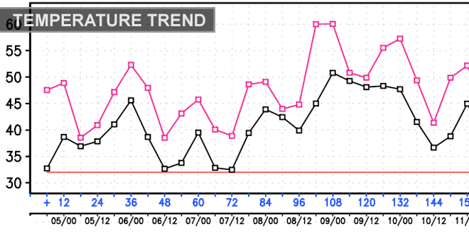
The temperature moderated into the upper 40s to low 50s on Thursday afternoon with plenty of sunshine and a west-southwest breeze in Southern New England. Clouds will increase Thursday night in advance of a storm that will slide out to sea south of Nantucket on Friday. The storm will come close enough to bring light rain showers to the I-95 corridor Friday morning. There is a better chance of steady rain from the coast of RI through Buzzards Bay, Cape Cod, and the islands.
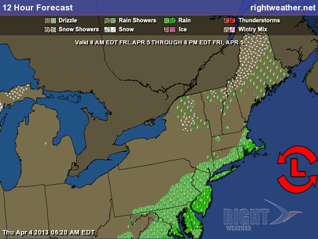
Any rain should end by early in the afternoon, and clouds may begin to clear before sunset. The temperature will rise from the low 40s in the morning to the low to mid 50s inland, and upper 40s near the coast in the afternoon. The best weather in Southern New England on Friday will be from Northern CT to Central/Western MA and far NW RI. Those areas should have minimal impact from the storm, and may see a decent dose of sunshine with seasonably mild temps.
Saturday looks bright and seasonably cool. There should be plenty of sunshine, a northwest breeze, and highs near 50. It will stay dry on Sunday, with a few more clouds – especially in the afternoon. Low temperature will be in the upper 20s to low 30s, and afternoon highs will be in the low to mid 50s. The overall weather pattern will begin to shift early next week. While an extended period of very warm weather is unlikely, there may be a day or two with temperatures in the 60s to low 70 inland, and 50s to low 60s near the coast. Monday looks partly sunny with highs in the mid to upper 60s inland, and 50s to low 60s near the coast. Clouds will increase during the afternoon, and some showers are possible at night. Tuesday will be a bit cooler, with highs in the 50s near the coast, and near 60 inland.
Wednesday through Friday is not looking as nice, with a slow-moving weather system having an impact in the Eastern United states late next week. The temperature will likely be settling back into the 40s and 50s with thicker clouds and some rain.


