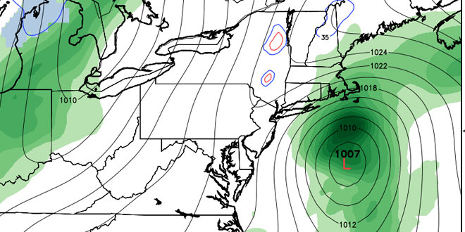
A very strong area of high pressure over the Northeastern United States kept the sky clear through midday Monday. Meanwhile, a storm was developing off the Florida coast. That storm is expected to move north and bring some showers to Southeastern New England on Tuesday. Clouds will gradually increase through Monday night, with the chance of some stray showers by dawn Tuesday. Lows will be near 40°.

Tuesday looks unseasonably cool, with a gusty northeast breeze, and plenty of clouds. There will also be some rain, especially in the afternoon and evening in Eastern Massachusetts. In Rhode Island, expect showers, steadiest late in the day. In Eastern Massachusetts, it looks like morning showers will give way to steady rain in the afternoon and evening. The temperature will most likely not reach 50°, and the combination of clouds, showers and 15-30 mph winds will make it feel even colder. Rain should end before dawn on Wednesday.
Wednesday looks like a decent day with partly to mostly sunny skies and highs in the mid 60s inland, and close to 60 near the coast. A cold front will move through Wednesday night or Thursday. Some showers are possible as the passes. Right now, it looks like the best chance of seeing rain is between midnight and noon on Thursday. Highs will be close to 60°.
The outlook for the weekend is decent. Friday should be dry and seasonable, with highs in the low 60s. Saturday will probably be the sunnier of the two weekend days, but it should be dry or mainly dry on Sunday. Highs will be within a few degrees of 60 both days.


