The weather improved dramatically on Memorial Day in Southern New England. After a chilly start ranging from the mid 30s to low 40s, the temperature jumped into the mid 60s near the coast, and low 70s inland with cloud-free skies in the afternoon. It was breezy and very dry, with dew points in the 30s and a 10-20 mph northwesterly breeze. Monday night will be another cool night in Southern New England. As the wind relaxes under clear skies, the temperature will drop into the low to mid 40s by dawn Tuesday.
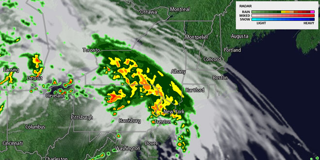
Tuesday morning should feature a lot of blue sky, with high, thin clouds rolling in during the afternoon. It may be overcast by the time the sun sets at 8:11 pm. The clouds will arrive in advance of showers and thunderstorms that should move through late Tuesday night through midday Wednesday. It is too early to say if there is a severe weather threat with the thunderstorms on Wednesday, but some computer models are showing the potential for some torrential downpours. The heaviest rain is likely to move through by midday Wednesday. It will be in the upper 60s to low 70s on Wednesday afternoon. The showers/storms come with a warm front signifying the leading edge of instant-summer weather that hits Southern New England by Thursday afternoon.
Wednesday night looks damp and mild with some patchy fog. Lows will be in the low 60s. The fog should burn off on by mid-morning Thursday, and the temperature will respond to the late-May sunshine, with highs in the mid to upper 80s inland. The temperature near the coast will be highly dependent on the wind direction – if it’s out of the south or southwest it will stay in the 70s, if it is west or northwest, than it will reach the 80s. The odds favor the wind turning onshore in the afternoon, keeping it from getting too warm at the beaches.
Mid-summer heat is in the forecast from Friday through next weekend. A very warm, muggy airmass will continue to overspread the Mid-Atlantic and New England. Highs will be in the mid to upper 80s inland, and near 80 at the coast. It may feel a bit warmer because of the humidity. The muggy airmass will not allow the temperature to fall very much at night, and lows in the mid to upper 60s inland are likely. Because the ocean is still near 60°, the overnight low temperature near the coast may reach the low 60s. Some patchy dense fog is likely at night through mid-morning Friday to Sunday. A west to southwesterly breeze can be expected each day. The warm stretch will most likely come to an end late in the weekend or early next week as a cold front brings showers and thunderstorms.


