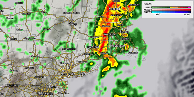
Torrential showers and thunderstorms over New York and Western New England Thursday afternoon will move east Thursday night into Southeastern New England. As of early Thursday evening, there were no rain-related Flood Watches or Warnings in effect for Southeastern New England. It is a situation that needs to be monitored through Friday morning as the potential exists for some poor drainage flooding as a result of torrential downpours. There is a Coastal Flood Advisory in effect for Thursday evening at the time of high tide in the area around Narragansett Bay. Astronomically high spring tides combined with a southwesterly wind may lead to some minor flooding between 6-9 pm.
Heavy showers and thunderstorms are likely after midnight in Southeastern New England. The heaviest rain will move from Rhode Island into Southeastern Massachusetts by mid-morning on Friday. There may be some dry weather in the wake of the heavy rain around midday Friday. Any dry stretch will not last for too long. Another area of moderate to heavy rain is likely to move into Southern New England Friday night. The temperature will be in the 60s on Friday afternoon. As the wind swings around to the north-northeast, the temperature will drop into the low 50s by early Saturday morning.
Saturday looks showery and cool. There will be a northerly breeze between 10-25 mph, with some stronger gusts possible near the coast. The temperature will hover in the low to mid 50s. It does not look like there will be much change Saturday night into Sunday morning. The temperature may dip into the 40s after sunset. Cool rain showers will linger on Sunday. It will most likely not be a total washout, but it will not be your typical late-May day with highs only in the 50s. The best chance of showers Sunday is in the morning.
The weather will finally improve late Sunday into Memorial Day. It will stay cool through Sunday night, with lows in the 40s to low 50s. Monday looks partly to mostly sunny with highs in the mid to upper 60s. It will continue to get warmer in the middle of next week. The high temperature should reach the 70s inland on Tuesday and Wednesday. An onshore breeze may keep it in the mid to upper 60s near the coast.


