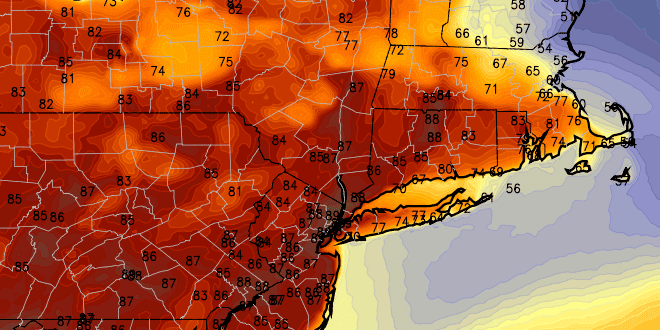
Patchy, dense fog is likely early Tuesday morning as the mild, muggy airmass remains in place over Southern New England. The clouds and fog should burn off to a mostly cloudy sky inland. Near the coast, the clouds and fog may be stubborn for a good chunk of the day. The wind will be out of the south-southeast on Tuesday. That is a cooler wind direction than RI and SE MA saw on Monday when the temperature jumped into the 80s inland. Highs will be in the low to mid 70s inland, and mid to upper 60s near the coast. There is a chance it reaches the 80s inland again, but there will need to be some sunshine for that to occur.
A front will be sagging south on Tuesday, and scattered showers and thunderstorms may develop during the afternoon and evening. It will once again become mild and humid with some patchy fog Tuesday night into early Wednesday. Wednesday may be similar to Monday away from the coast as a southwest wind develops. Highs will be in the mid to upper 70s inland, and upper 60s to low 70s near the coast. There should be some sunshine on Wednesday – especially away from the coast.
A cold front will threaten Southern New England with showers and thunderstorms on Thursday into early Friday. Conditions may be ripe for strong storms inland if there is some sunshine preceding the front on Thursday. Sun is not a certainty on Thursday, and the timing of the front may be such that clouds increase early in the day, limiting the potential for strong inland storms.
Cooler weather will arrive for the Memorial Day weekend. Saturday should be partly sunny with highs in the 60s and lows in the 40s. It will be similarly cool on Sunday. Right now, it looks like it will stay dry through the holiday and into the middle of next week.


