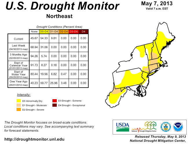
The lack of precipitation over the past couple of months has part of Southern New England in a Moderate Drought while most of the rest of the area is experiencing Abnormally Dry conditions. Most of Connecticut is in a Moderate Drought – the lowest classification on the Drought Conditions scale. A Moderate Drought is also being experienced in Western RI and most of Central and Western MA. The drought is not expected to intensify in the coming weeks because of a shift to a wetter pattern compared to the past few weeks. The following is from the U.S. Drought Monitor National Drought Summary released on May 7, 2013:
New England and mid-Atlantic: Strong high pressure off the Northeast coast kept much of the region precipitation free until after the cut off period (12Z Tuesday), further increasing short-term shortages. With many areas receiving less than half of normal precipitation at 30 and 60 days, and under 70 percent at 90 days, deficits at 30, 60, and 90 days rose to between 2 and 4, 3 and 6, and 4 to 7 inches, respectively. Accordingly, D0 was expanded northward and southward, now stretching from central Maine southward into southern West Virginia. In addition, where the deficits were the greatest at 90 days (northern West Virginia and south-central new England), and where the average USGS stream flows at 1, 7, and 14 days were below the tenth percentile (many at record lows on May 6), D1 was added. Fortunately, this is a time of year when stream flows can respond quickly to a good soaking. With southern New England still only one-third to one-half through green-up, the impacts of dry weather were not as obvious as they would be later in the spring. The dry weather, however, has elevated fire weather conditions in the interior.


