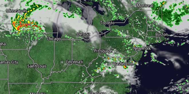
Rain soaked Southern New England saw another round of showers and thunderstorms Tuesday afternoon and evening. The back edge of the system that brought a widespread 2″+ rainfall Monday night spun up more showers on Tuesday. The showers will be gone by dawn, and there may even be some clearing by sunrise. Lows will be in the mid to upper 50s early Wednesday morning.
Wednesday looks like a pretty nice day, with sun and clouds, and highs in the low to mid 70s. There will be a northwesterly breeze at 10-25 mph, and the humidity will be low. Enjoy the break in the action because another potent storm system is in the forecast for late in the workweek. It will stay dry through Wednesday night. Clouds will increase late at night, and the temperature will be comfortably cool, with lows in the low to mid 50s.
Nor’easter-like storm Thursday-Friday
The wind will swing around to the northeast by late Wednesday night as a storm moves through the Mid-Atlantic states. That storm is likely to cut just south of Southern New England, bringing rain back to CT, RI, and MA Thursday afternoon into, at least, Friday morning. Thursday will be a breezy, cool day, with the chance of showers by midday, and rain likely by sunset. Highs will only be in the mid to upper 60s, and it will turn cooler once the rain begins.
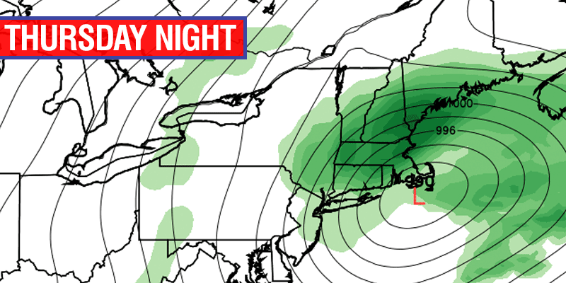
Thursday night looks breezy to windy, rainy, and cool. Lows will be in the low to mid 50s with an east-northeasterly wind that may gust over 35 mph near the coast. The rain could be heavy at times depending on the exact track of the storm. Rain will continue into Friday morning before tapering off during the day as the storm moves east of Southern New England. It will be unseasonably cool on Friday, with highs only in the upper 50s to low 60s. There is the potential for another 1-3″ for rain from the Thursday-Friday storm. It may be enough to push this month into the top three wettest months of June on record in the Providence area.
Fine Father’s Day weekend
Thankfully, the weather will improve quite a bit for the Father’s Day weekend. High pressure will move in behind the departing storm, and both Saturday and Sunday will feature sunshine. It will be just a bit cooler than normal, with highs near the coast in the low 70s. It will reach the mid 70s inland. The air will be dry, so overnight lows will be in the 50s. Looking ahead to next week…there may be more rain to deal with Monday night into Tuesday.


