
It is fitting that June 2013 ends with a fresh round of showers developing over Southern New England. It was among the top-3 wettest months of June on record in most of Southern New England, and it is likely to finish as the second wettest since 1905 in the Providence area.
Rain will be a theme to start July, with occasional showers and thunderstorms in the forecast for both Monday and Tuesday. While it will not be raining the entire time, there is the potential for some heavy downpours with very humid air remaining entrenched in the Northeast. Monday will be mostly cloudy with the best chance of showers in the morning near the coast, and inland in the afternoon and evening. It will be breezy and muggy with highs in the 70s.
Showers and storms are possible Monday night into Tuesday as a front remains draped just to the west of Southern New England. Once again, it will be mild and humid, with low temperatures in the mid to upper 60s and highs in the mid to upper 70s. The highest likelihood of showers and storms Tuesday afternoon is away from the coast.
The weather should improve by the middle of the week, and the forecast for the 4th of July is not looking too bad. After a cloudy start, Wednesday should become partly sunny. It will be seasonably warm and quite humid with highs in the low to mid 80s inland, and mid to upper 70s near the coast. There will be a southwesterly breeze between 10-20 mph, and the surf will remain fairly high at area beaches. Pop-up showers and thunderstorms are possible inland.
Very warm, muggy 4th of July
The FourthCast is looking decent, with hazy sunshine and highs well into the 80s inland. It will be cooler near the coast as the southwesterly breeze prevails again. There is a low chance of pop-up showers and t-storms inland on Thursday afternoon. Look for highs in the mid 80s inland, and near 80 at the coast. It may feel a bit warmer because of the humidity.
Low clouds and fog may move into the coast both Wednesday and Thursday night. It is something to keep an eye on with fireworks displays scheduled throughout Southern New England. It will remain very humid at night, with lows in the mid 60s near the coast and close to 70 inland.
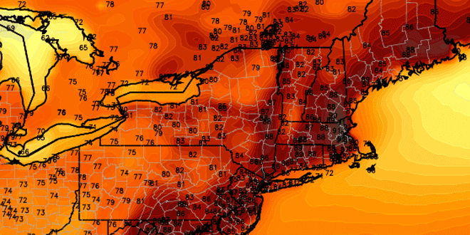
The late-week forecast features more very warm, humid weather. The early indications are that inland high temps may flirt with 90° Friday and, at least, part of next weekend. While very warm, it’s nothing compared to the kind of heat they are seeing in the desert Southwest.
Cover photo on home page by 02809photo.com


