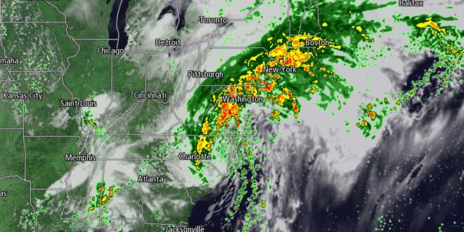
Rain was overspreading Southern New England Thursday night as Tropical Storm Andrea moved across the Southeastern United States. A disturbance in the jet stream is drawing the tropical moisture from the storm north into the Northeastern United States. The remnant circulation of Andrea is likely to pass over or just south of Southern New England Saturday morning. The main threat in Southern New England over the next couple of days is flooding. At this point, it does not look like there will be extensive river flooding, but street and poor drainage flooding should occur after 2-3″ of rain Friday through early Saturday morning. The National Weather Service has issued a Flood Watch for most of Southern New England.
[/raw]
Storm/Weekend Timeline
Friday
Occasional rain is likely on through the day. The rain may become heavy at times in the afternoon. It will be unseasonably cool with temperatures in the 50s to low 60s. The breeze will increase out of the east to 15-25 mph near the coast by late in the day. 0.5-1.0″ of rain is possible by late Friday afternoon.
Friday Night
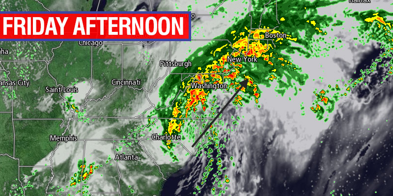
The rain will become heavier Friday night as the center of Andrea’s circulation approaches Southern New England. Some torrential downpours are possible, and if you have plans to head out Friday evening, be aware of the potential for flooded roads and ponding on highways. 1-2.5″ of rain is possible from sunset Friday to sunrise on Saturday morning. The wind will increase near the coast to 15-30 mph, with the potential for some 30-50 mph wind gusts on Cape Cod and Nantucket. The strong wind potential is highly dependent on the exact track of the storm. If it tracks a bit farther east, the strong wind potential diminishes since the strongest winds will be on the eastern side of the storm. If you like sleeping on a rainy night, then you’ll love Friday night! A good chunk of Southern New England will be in the “car wash” for most of the night, no need to take out the pressure washer guide by ToolsMaestro this weekend!
Saturday
It will likely be quite rainy as the sun rises Saturday at 5:11 am. The storm will be moving quickly, and the rain will end abruptly sometime between shortly after sunrise and mid-morning. Another 0.25-0.5″ of rain is possible between 5-10 am Saturday. The current forecast has the rain ending by around 8 am in RI and by 10 am in Eastern MA. The weather should improve dramatically by midday Saturday as the storm departs on Saturday. Look for some breaks in the clouds with the temperature climbing into the upper 60s to low 70s. One feature we’ll be keeping a close eye on is a disturbance trailing behind the remnants of Tropical Storm Andrea. Another round of showers is possible late Saturday into Saturday night.
Sunday
Sunday looks decent, with partly cloudy skies and highs in the mid to upper 70s inland. It will be in the low to mid 70s near the coast. There is the chance of a brief passing shower, but most of the day will be dry.
Real-life impacts
- Most outdoor activities on Friday or Friday night will likely be washed out by steady then heavy rain.
- Travel could be impacted Friday afternoon through Friday night because of heavy downpours and street flooding.
- Some weekend events could continue to be affected after the rain ends. For instance, poor draining athletic fields and yards will remain waterlogged if the storm delivers on its promise of 2-4″ of rain.
- Gale Watches and Warnings are in effect for the waters south of Southern New England. The storm should bring enough wind and rough seas to make offshore boating hazardous Friday night through midday Saturday
Looking ahead to next week, the weather could go downhill as soon as late Monday when another storm system moves from the Great Lakes to the Northeast. Showers are likely in the midweek. It will likely be cooler than normal Tuesday through Thursday.


