The National Weather Service has determined that the May 31, 2013 El Reno, OK tornado was the widest on record in the United States at 2.6 miles across. The previous record was a 2.5 mile tornado that hit Hallam, Neb in May of 2004. The El Reno, OK tornado was also upgraded from an EF-3 rating to an EF-5 with maximum winds of 296 mph. The winds were estimated by the University of Oklahoma’s Rapid X-Pol mobile doppler.
The tornado and corresponding thunderstorm contributed to 18 fatalities in the El Reno area, about 25 miles west of Oklahoma City. The thunderstorm produced grapefruit-sized hail and flash flooding.
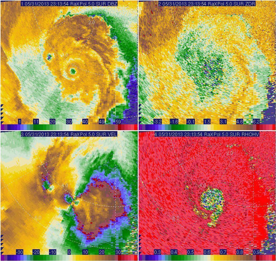
More information from the National Weather Service in Norman, OK on the El Reno tornado.
MAXIMUM WIDTH
- The tornado was at least 2.6 miles wide.This is likely conservative.
- Damage indicators were sparse, so it was difficult to estimate the maximum width of the tornado based on the ground survey.
- However, we were able to use mobile Doppler radar velocity data to estimate the path width.
- We used a Doppler radar radial velocity of 65 mph – corresponding to the threshold of EF0 tornadic winds – to help estimate the tornado width.
MAXIMUM INTENSITY
- The tornado struck mostly rural areas of Canadian County, leading to difficulty establishing maximum intensity.
- Initial estimate of EF3 was based on damage to several structures, but the inferred tornado intensity was an underestimate of tornado strength because of the scarcity of damage indicators and very small regions of extreme winds.
- However, two high-resolution mobile radars acquired high detail datasets of the tornado.
- The University of Oklahoma’s RaXPol, a rapid-scan, polarimetric, mobile Doppler radar, measured winds greater than 295 mph at several times and locations within 500 feet of the ground along the south side of subvortices on the south side of the tornado.
- These extreme velocities occurred several times in the RaXPol data.
- Extreme winds associated with small, rapidly-translating subvortices within the larger tornadic circulation.
- These intense subvortices remained over open fields and did not directly affect structures.
- The two most intense subvortices with the highest velocities occurred north and east of the intersection of 10th and Radio Road approximately 3 miles SSE of El Reno.
- The observation of winds well above the EF4/EF5 boundary from two independent rapid-scan mobile radars lends confidence to the observed winds.
- Known damage indicators were compared to RaXPol velocity measurements; good agreement was found between EF-scale rating and velocities above.
PUBLIC INFORMATION STATEMENT
NATIONAL WEATHER SERVICE NORMAN OK
1206 PM CDT TUE JUN 4 2013

...UPDATE ON MAY 31 EL RENO TORNADO...

METEOROLOGISTS WITH THE NATIONAL WEATHER SERVICE AND RESEARCHERS FROM
THE UNIVERSITY OF OKLAHOMA CONTINUE TO INVESTIGATE INFORMATION
RELATED TO THE MAY 31 EL RENO TORNADO.

WITH THIS INVESTIGATION... THE TORNADO HAS BEEN UPGRADED TO AN EF5
TORNADO BASED ON VELOCITY DATA FROM THE RESEARCH MOBILE RADAR DATA
FROM THE UNIVERSITY OF OKLAHOMA RAXPOL RADAR. IN ADDITION... THE
WIDTH OF TORNADO WAS MEASURED BY THE MOBILE RADAR DATA TO BE 2.6
MILES AFTER THE TORNADO PASSED EAST OF US HIGHWAY 81 SOUTH OF EL
RENO. THIS WIDTH IS THE WIDTH OF THE TORNADO ITSELF AND DOES NOT
INCLUDE THE DAMAGING STRAIGHT-LINE WINDS NEAR THE TORNADO AS
DETERMINED BY THE HIGH-RESOLUTION MOBILE RADAR DATA. THE 2.6 MILE
TORNADO PATH WIDTH IS BELIEVED TO BE THE WIDEST TORNADO ON RECORD
IN THE UNITED STATES.

.EL RENO TORNADO

RATING:                  EF5
PATH LENGTH /STATUTE/:   16.2 MILES
PATH WIDTH /MAXIMUM/:    2.6 MILES
FATALITIES:              N/A
INJURIES:                N/A

START DATE:              MAY 31 2013
START TIME:              6:03 PM CDT
START LOCATION:          8.3 WSW OF EL RENO /CANADIAN COUNTY /OK
                           NEAR COURTNEY ROAD ABOUT 1 MILE NORTH
                           OF REUTER ROAD
START LAT/LON:           35.495 / -98.095

END DATE:                MAY 31 2013
END TIME:                6:43 PM CDT
END LOCATION:            6.2 ESE OF EL RENO /CANADIAN COUNTY /OK
                           NEAR INTERSTATE 40 AND BANNER ROAD
END LAT/LON:             35.502 / -97.848

$$

SMITH/GARFIELD/SPEHEGER/AUSTIN
http://youtu.be/vw3YYawGZTw