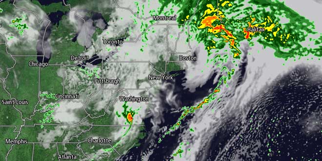
The weather will improve dramatically following the super soaking rain storm featuring the remnants of Tropical Storm Andrea. Much of CT, RI and interior SE MA picked up 3-5″ of rain in about 30 hours. There was officially 4.1″ of rain at TF Airport through 5am Saturday. At the Right Weather World HQ in Bristol, RI, the final storm total was 4.35″. Here is the latest list of reports from the National Weather Service: http://goo.gl/XP9Zl
The heavy rain moved out around dawn on Saturday. Yards, parks, and athletic fields may still be waterlogged on Saturday, but there should be some in and out sunshine with highs in the low to mid 70s. The wind will swing around to the west at 10-15 mph. That wind direction will help to usher in drier air. Saturday night looks mainly clear and seasonably mild, with lows in the mid to upper 50s.

Sunday should be the nicer weekend day, with highs in the upper 70s to low 80s under mostly sunny skies. It will turn a bit cooler in the afternoon near the coast as the wind turns onshore. A slow-moving storm in the Upper Midwest is going to play a big role in the early to midweek weather in Southern New England. The timing on the system is not set in stone, and it’s unclear if showers will arrive during the day Monday or hold off to Monday night into Tuesday. For now, the forecast is for partly to mostly cloudy skies with the chance of showers or thunderstorms – primarily in the afternoon. Highs will be in the 70s.

The bowling ball upper-level low pressure system will roll into the Northeast in the midweek. The result will be pop-up showers and thunderstorms Tuesday, Wednesday, and possibly Thursday. The relatively cool air aloft combined with strong late-spring sunshine will lead to cloud and shower development. The showers will be hit and miss, and there should be extended dry stretches between bursts of rain. Highs will stay in the low to mid 70s. Lows will be in the upper 50s to low 60s.
Looking way down the road, the weather will likely improve late in the work week. A storm over the Mid-Atlantic will need to be watched next weekend. There is some potential for it to drift north bringing another round of rain at some point over the Father’s Day weekend.


