Tuesday was delightfully dry with with highs in the low 70s and very low humidity. The active northwesterly breeze will diminish by dawn Wednesday. After starting the day in the 40s to low 50s, the temperature will climb back into the low to mid 70s on Wednesday afternoon. There will be a blend of clouds and sun in Southern New England. An afternoon sea breeze will kick in, and that will knock the coast back into the mid to upper 60s by late in the day.
The weather will likely stay dry on Thursday. Once again, look for a blend of sun and clouds, with a trend toward more clouds during the afternoon. It will be a bit cooler than normal with highs in the upper 60s near the coast and low 70s inland. There will be a steady south-southeasterly breeze.

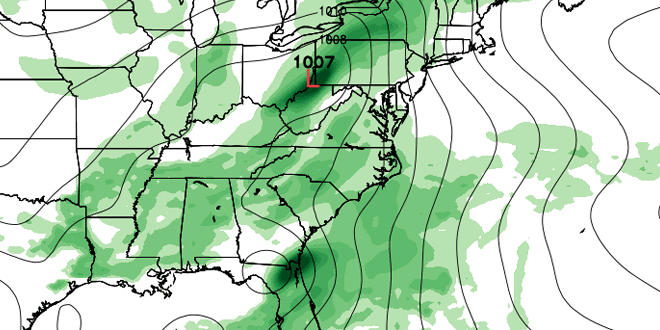
A storm will continue to develop in the Gulf of Mexico over the next couple of days. As of 5 pm Tuesday, the National Hurricane Center gives the system a 40% chance of developing into Tropical Storm Andrea within the next 48 hours. The storm will bring a drenching rain to Florida before getting caught in the jet stream and heading up the Eastern Seaboard. While the exact track of the storm is still in question, the odds of a soaking rain are increasing for part or all of Southern New England.

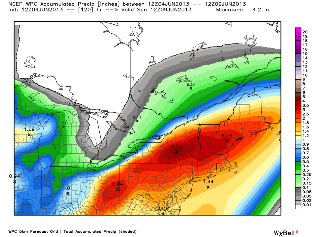
Rain is possible by late Thursday night as moisture ahead of the Gulf of Mexico storm interacts with jet stream. Rain will likely overspread Southern New England during the day on Friday. It may be heavy by the afternoon. Highs will be in the mid to upper 60s with a gusty onshore breeze on Friday. The storm will move steadily up the Eastern Seaboard Friday afternoon and night, and the potential exists for moderate to heavy rain into early Saturday morning. Early estimates are for 2-4″ of rain in Southern New England, with the potential for some flash flooding.
Some of the latest computer model guidance has the storm moving north of Southern New England by midday Saturday. If that scenario plays out, then most of Saturday will be dry, with just the chance of some pop-up afternoon showers. With a bit of sunshine, the temperature would easily reach the low to mid 70s on Saturday. Don’t go canceling those outdoor plans just yet, but be aware that the ground may be soaked even if the heavy rain ends by mid-morning Saturday.
At this point, Sunday looks ok, with a blend of clouds and sun, and highs int he 70s. Another rainmaker will approach from the west by late Sunday, and next week may begin with more showers in Southern New England.


