Packing 60 mph and a flooding, storm surge, and tornado threat Tropical Storm Andrea was about 100 miles off the Gulf Coast of Florida late Thursday morning. The storm is expected to move inland in the Big Bend area of Florida late Thursday as a tropical storm with 50-60 mph maximum sustained winds. The storm will continue to move northeast and bring heavy rain to the Eastern Seaboard as it heads to New England by late Friday night.
1 horse killed, 2 dogs unaccounted for after reported tornado flattens barn in Myakka City, owners tell FOX 13. pic.twitter.com/8WQNRdAJ5T
— FOX 13 Tampa Bay (@FOX13News) June 6, 2013
The storm may weaken slightly as it moves up the East Coast, and widespread strong winds or tornadoes are not a big threat for Southern New England due to the storm’s track. Flooding rain, however, is a concern for Southern New England based on the latest forecasts for Andrea. A Flood Watch may be issued on Thursday for part or all of Southern New England.
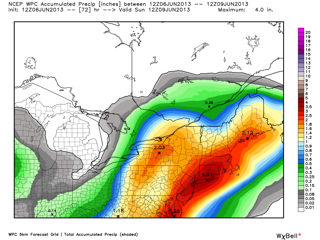
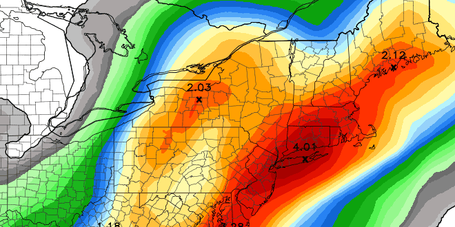
The disturbance that will steer Andrea to the northeast will arrive in New England on Friday. Rain will break out well in advance of the storm, and some heavy downpours are possible during the day Friday – especially in the afternoon. As the storm’s center closes in on Southern New England, moderate to heavy rain will continue. The heaviest rain is likely to be just northwest of the storm’s center. It is still unclear where the heaviest rain will be in Southern New England. Climatologically, the favored areas are CT, interior MA, and most of RI. There is a lower chance of heavy rain in coastal SE MA if the storm tracks right over RI or SE MA. Right now, it looks like the hardest hit areas will receive between 2-4″ of rain. The lowest totals will likely be between 0.5-1″ of rain – still a good soaking, but not enough for flooding. Areas that see more than 2″ of rain will see some street and small stream flooding. If the totals approach 4″, there is the possibility of minor river flooding.
Important links
- The FREE RightWX app for your iOS/Android device
- 15 Second Forecast
- Interactive Radar
- Hurricane Tracker
- Beach Forecasts
Impacts on the weekend
- Heaviest rain ends between 5-10 am Saturday. Right now, we are leaning toward the heavy rain ending before 8am in RI.
- Rain will be heavy enough in many places to saturate yards and athletic fields – even though rain ends and sun comes out, fields may still have standing water Saturday afternoon and Sunday
- The weather should improve considerably Saturday morning – some sunshine and temperatures in the 70s by noon
- There is not much of a strong wind threat for most of SNE – the exception may be for a few hours late Friday night on the Cape/Islands
- A round of showers or thunderstorms is possible Saturday afternoon or evening as a trailing disturbance moves through SNE
- Sunday looks decent, with sun/clouds and highs in the mid to upper 70s
Stay with rightweather.com for the latest on the rain/flood potential Friday into early Saturday.


