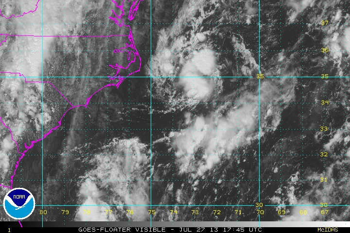
A small area of low pressure is being monitored by the National Hurricane Center for quick development in the next 12-18 hours as it moves north off the Mid-Atlantic Coast. The NHC is giving the system a 20% chance of becoming a tropical cyclone before it moves over cooler waters by mid-morning Sunday. Locally, the storm may clip eastern New England with showers and thunderstorms late Saturday night through mid-morning Sunday.
TROPICAL WEATHER OUTLOOK
NWS NATIONAL HURRICANE CENTER MIAMI FL
200 PM EDT SAT JUL 27 2013

FOR THE NORTH ATLANTIC...CARIBBEAN SEA AND THE GULF OF MEXICO...

THE NATIONAL HURRICANE CENTER IS ISSUING ADVISORIES ON TROPICAL
STORM DORIAN...LOCATED OVER THE TROPICAL ATLANTIC SEVERAL HUNDRED
MILES EAST OF THE NORTHERN LEEWARD ISLANDS.

1. A NON-TROPICAL AREA OF LOW PRESSURE HAS FORMED ABOUT 100 MILES EAST
OF THE NORTH CAROLINA OUTER BANKS.  SIGNIFICANT DEVELOPMENT OF THIS
SYSTEM IS UNLIKELY BEFORE IT MOVES OVER COLDER WATERS TOMORROW.
THIS SYSTEM HAS A LOW CHANCE...20 PERCENT...OF BECOMING A TROPICAL
CYCLONE DURING THE NEXT 48 HOURS WHILE IT MOVES GENERALLY TO THE
NORTH-NORTHEAST AT 15 TO 20 MPH.


