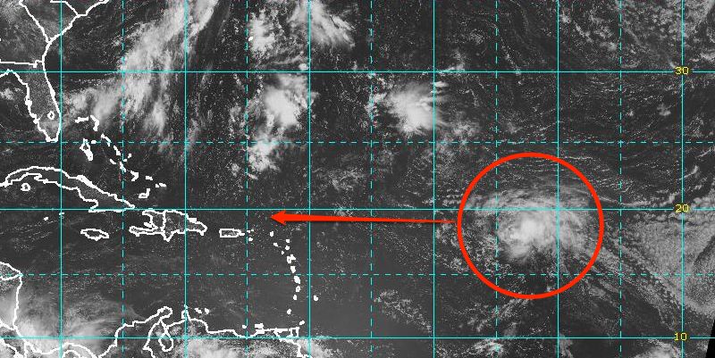
Tropical Storm Dorian has weakened to maximum sustained winds of 45 mph as it moves swiftly west-northwest at 21 mph through the Atlantic Ocean. As of 11 am, Friday, the storm was nearly 1,300 miles east of the northern Leeward Islands. The storm is not forecast to intensify significantly in the next several days as it continues on a general westerly track. The latest computer model forecast consensus is a bit farther south than previous projections. The forecast track is far enough south that the storm will have an impact in the Caribbean islands, but it is not expected to be a strong tropical storm or hurricane at that time. The storm will be encountering dry air and wind shear in the next couple of days, and may degenerate to a tropical wave.
Computer model forecasts for Tropical Storm Dorian
BULLETIN
TROPICAL STORM DORIAN ADVISORY NUMBER  10
NWS NATIONAL HURRICANE CENTER MIAMI FL       AL042013
1100 AM AST FRI JUL 26 2013

...DORIAN REMAINS DISORGANIZED WHILE MOVING QUICKLY
WEST-NORTHWESTWARD...

SUMMARY OF 1100 AM AST...1500 UTC...INFORMATION
-----------------------------------------------
LOCATION...17.7N 43.4W
ABOUT 1295 MI...2085 KM E OF THE NORTHERN LEEWARD ISLANDS
MAXIMUM SUSTAINED WINDS...50 MPH...85 KM/H
PRESENT MOVEMENT...WNW OR 285 DEGREES AT 21 MPH...33 KM/H
MINIMUM CENTRAL PRESSURE...1006 MB...29.71 INCHES

WATCHES AND WARNINGS
--------------------
THERE ARE NO COASTAL WATCHES OR WARNINGS IN EFFECT.

INTERESTS IN THE NORTHERN LEEWARD ISLANDS SHOULD MONITOR THE
PROGRESS OF DORIAN.

DISCUSSION AND 48-HOUR OUTLOOK
------------------------------
AT 1100 AM AST...1500 UTC...THE CENTER OF TROPICAL STORM DORIAN WAS
LOCATED NEAR LATITUDE 17.7 NORTH...LONGITUDE 43.4 WEST. DORIAN IS
MOVING TOWARD THE WEST-NORTHWEST NEAR 21 MPH...33 KM/H...AND A
GENERALLY WESTWARD MOTION AT A SLIGHTLY FASTER FORWARD SPEED IS
EXPECTED OVER THE NEXT 48 HOURS.

MAXIMUM SUSTAINED WINDS ARE NEAR 50 MPH...85 KM/H...WITH HIGHER
GUSTS.  SATELLITE IMAGES INDICATE THAT DORIAN IS NOT WELL
ORGANIZED...AND SOME WEAKENING IS FORECAST DURING THE NEXT DAY OR
SO.

TROPICAL STORM FORCE WINDS EXTEND OUTWARD UP TO 60 MILES...95 KM
FROM THE CENTER.

THE ESTIMATED MINIMUM CENTRAL PRESSURE IS 1006 MB...29.71 INCHES.

HAZARDS AFFECTING LAND
----------------------
NONE.


