The National Hurricane is watching a disturbance in the southwestern Caribbean Sea for potential tropical development in the next few days. Right now, the odds are low of the system becoming a tropical cyclone in the next five days. The disturbance will move to the north-northwest towards the Yucatán Peninsula into an area that is slightly more favorable for intensification.
The system has a 10% chance of becoming a tropical cyclone in 48 hours, and a 20% chance of becoming a tropical cyclone in the next five days. If it becomes a tropical storm, it will be the fifth named storm (Erin) of the 2013 Atlantic hurricane season.

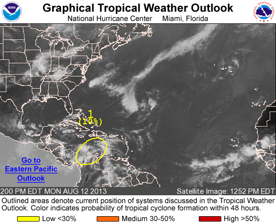
TROPICAL WEATHER OUTLOOK
NWS NATIONAL HURRICANE CENTER MIAMI FL
200 PM EDT MON AUG 12 2013

FOR THE NORTH ATLANTIC...CARIBBEAN SEA AND THE GULF OF MEXICO...

1. CLOUDINESS AND SHOWERS EXTENDING FROM THE SOUTHWESTERN CARIBBEAN SEA
NORTHEASTWARD TO NEAR HISPANIOLA ARE ASSOCIATED WITH A WESTWARD
MOVING TROPICAL WAVE AND A BROAD AREA OF LOW PRESSURE. UPPER-LEVEL
WINDS ARE FORECAST TO BECOME A LITTLE MORE CONDUCIVE FOR
DEVELOPMENT DURING THE NEXT SEVERAL DAYS AS THE DISTURBANCE MOVES
TOWARD THE YUCATAN PENINSULA AND THE SOUTHERN GULF OF MEXICO. THIS
SYSTEM HAS A LOW CHANGE...NEAR 10 PERCENT...OF BECOMING A TROPICAL
CYCLONE DURING THE NEXT 48 HOURS...AND A LOW CHANCE...20 PERCENT...
OF BECOMING A TROPICAL CYCLONE DURING THE NEXT 5 DAYS.


