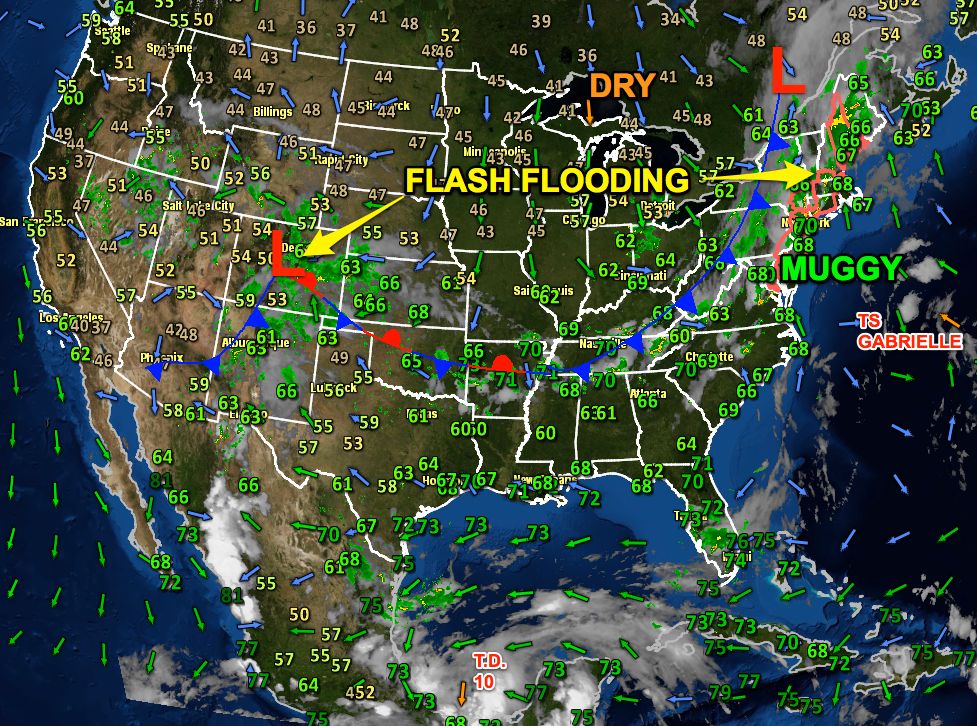
Prior to Thursday, this week had already featured some extreme weather in the United States. An unusually hot and humid airmass spread east from the Plains to the Northeast. Highs were in the 90s, and the humidity made it feel like 105°+. On Thursday, a strong cold front that will bring fall-like weather to the Upper Midwest and Northeast was responsible for wild weather from the Great Lakes to New England. Dual waterspouts were spotted on Lake Michigan. Flash flooding occurred in Keene, NH after a half-foot of rain. A thunderstorm from the same cold front delivered a lightning strike that knocked out the control tower temporarily at BWI Airport in Baltimore, MD.
At the same time, a slow-moving area of low pressure was leading to upslope conditions in the Front Range of the Rockies. Epic flash flooding was occurring in the Denver/Boulder area of Colorado.
The tropics have also come to life. The first hurricane of the season, Humberto, is way out in the eastern Atlantic Ocean. There are two other tropical cyclones that are closer to North America. Tropical Storm Gabrielle is moving north toward Nova Scotia where it will bring windy and wet weather. The bigger weather story will probably come from Tropical Depression Ten which may become Tropical Storm Ingrid as it meanders around in the Bay of Campeche off the eastern Mexico coast. The storm has the potential to bring one to two FEET of rain to an area that is prone to flash flooding and mudslides.

Check out some of the social media updates on the wild weather…
Waterspouts
One more impressive shot. This one from Paul Crimo who photographed two waterspouts off Kenosha. pic.twitter.com/nLgLe0IwSC
— Skilling (@Skilling) September 12, 2013
Colorado
Legal in Fall River…MT @AlexisNeely: Cop stops dad from pulling kid across Boulder park on wake board w/ dirt bike. http://t.co/nRXBhszjxS
— Fred Campagna (@FredCampagna) September 12, 2013
Prob. not engineering students. MT @KDVR: Neighbors at 7th/Arapahoe in Boulder set a barricade against floodwaters. pic.twitter.com/uEX5P0TxLt
— Fred Campagna (@FredCampagna) September 12, 2013
From a viewer in Lyons. Wow. #9news. #boulderflood pic.twitter.com/wuvxr16ZqX
— Chris Vanderveen (yep…me) (@chrisvanderveen) September 12, 2013
What's left of the street I grew up on #boulderflood pic.twitter.com/HxWMXqIiD0
— Jared Polis (@jaredpolis) September 12, 2013
Bad news for music fans: Planet Bluegrass appears to have been utterly wiped out. #boulderflood pic.twitter.com/hUkJZKDmtg
— Trevor Hughes (@TrevorHughes) September 12, 2013
Keene, NH
More rain is on the way RT @ryanbretonwx @nickabbott3 Downtown Keene pic.twitter.com/rSk4q7XkT7 #nhflood #NHwx
— NWS Boston (@NWSBoston) September 12, 2013


