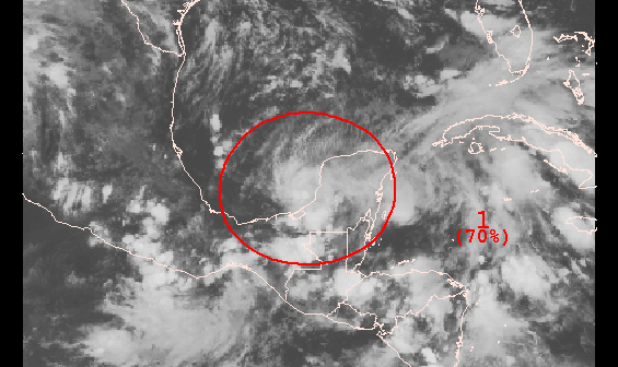
Another tropical wave is crossing the Yucatán Peninsula and heading for the southwestern Gulf of Mexico. This area has been a fertile breeding ground for tropical cyclones this season. The most recent storm, Ingrid, brought flooding rain, pounding surf, and strong winds to eastern Mexico last week. The current system that the National Hurricane Center is monitoring will move into the Gulf of Mexico in the next couple of days. Conditions will be favorable for a tropical storm to form. The National Hurricane Center gives this system a 70% chance of forming before Friday evening, and an 80% chance of forming in the next five days.
In the long-range, the storm is forecasted by many models to curve east toward the Southeastern United States. Right now, it looks like it will stay south of Southern New England if it moves into the Atlantic Ocean early next week.
Computer model forecasts for Invest 95
From the National Hurricane CenterTROPICAL WEATHER OUTLOOK NWS NATIONAL HURRICANE CENTER MIAMI FL 800 PM EDT WED SEP 18 2013 SHOWERS AND THUNDERSTORMS HAVE BEEN INCREASING NEAR AN AREA OF LOW PRESSURE OVER THE EXTREME SOUTHWESTERN GULF OF MEXICO JUST WEST OF THE YUCATAN PENINSULA. ENVIRONMENTAL CONDITIONS ARE EXPECTED TO BE CONDUCIVE FOR THE FORMATION OF A TROPICAL DEPRESSION ON THURSDAY... AND AN AIR FORCE RESERVE HURRICANE PLANE IS SCHEDULED TO INVESTIGATE THIS LOW TOMORROW. THIS SYSTEM HAS A HIGH CHANCE...70 PERCENT...OF BECOMING A TROPICAL CYCLONE DURING THE NEXT 48 HOURS WHILE IT MOVES TO THE WEST-NORTHWEST AT 5 TO 10 MPH...AND A HIGH CHANCE...80 PERCENT...OF BECOMING A TROPICAL CYCLONE DURING THE NEXT 5 DAYS. THIS DISTURBANCE WILL LIKELY SPREAD HEAVY RAIN OVER PORTIONS OF EASTERN AND SOUTHERN MEXICO AND COULD CAUSE LIFE- THREATENING FLOODS AND MUDSLIDES OVER AREAS ALREADY IMPACTED BY TORRENTIAL RAIN DURING THE PAST SEVERAL DAYS.


