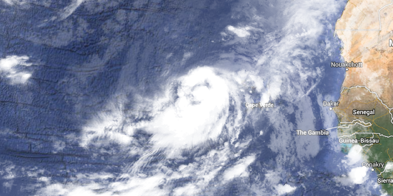
The long-awaited first hurricane of the Atlantic season finally formed Wednesday morning, just a few hours before a record would have been established for latest first hurricane of the season in the satellite era. Hurricane Humberto formed in the Eastern Atlantic Ocean at 5 AM EDT on Wednesday, September 11, 2013 – just 3 hours before Hurricane Gustav became the first hurricane of the 2002 season.
Latest first hurricane of season (since 1960)
1. Gustav, 9/11/2002 (8am)
2. Humberto, 9/11/2013 (5am)
3. Diana, 9/10/1984
4. Erin, 9/8/2001
As of 5 am, Humberto is a minimal hurricane with maximum sustained winds of 75 mph. It is no threat to land as it moves NNW in the Eastern Atlantic Ocean. A sharp turn to the west is forecasted by the National Hurricane Center after three days. At that point, it will still be thousands of miles from land.
Computer model forecasts for Hurricane Humberto
HURRICANE HUMBERTO ADVISORY NUMBER  11
NWS NATIONAL HURRICANE CENTER MIAMI FL       AL092013
500 AM AST WED SEP 11 2013

...HUMBERTO BECOMES THE FIRST HURRICANE OF THE SEASON OVER THE FAR
EASTERN ATLANTIC...

SUMMARY OF 500 AM AST...0900 UTC...INFORMATION
----------------------------------------------
LOCATION...16.0N 28.9W
ABOUT 310 MI...500 KM WNW OF THE SOUTHERNMOST CAPE VERDE ISLANDS
MAXIMUM SUSTAINED WINDS...75 MPH...120 KM/H
PRESENT MOVEMENT...NNW OR 330 DEGREES AT 8 MPH...13 KM/H
MINIMUM CENTRAL PRESSURE...992 MB...29.29 INCHES

WATCHES AND WARNINGS
--------------------
THERE ARE NO COASTAL WATCHES OR WARNINGS IN EFFECT.

DISCUSSION AND 48-HOUR OUTLOOK
------------------------------
AT 500 AM AST...0900 UTC...THE CENTER OF HURRICANE HUMBERTO WAS
LOCATED NEAR LATITUDE 16.0 NORTH...LONGITUDE 28.9 WEST. HUMBERTO IS
MOVING TOWARD THE NORTH-NORTHWEST NEAR 8 MPH...13 KM/H.  THE CYCLONE
IS EXPECTED TO TURN TOWARD THE NORTH AT A SLIGHTLY FASTER FORWARD
SPEED DURING THE NEXT TWO DAYS.

MAXIMUM SUSTAINED WINDS HAVE INCREASED TO NEAR 75 MPH...120
KM/H...WITH HIGHER GUSTS.  HUMBERTO COULD STRENGTHEN MORE TODAY
BEFORE A WEAKENING TREND LIKELY STARTS ON THURSDAY.

HURRICANE FORCE WINDS EXTEND OUTWARD UP TO 25 MILES...35 KM...FROM
THE CENTER...AND TROPICAL STORM FORCE WINDS EXTEND OUTWARD UP TO 115
MILES...185 KM.

THE ESTIMATED MINIMUM CENTRAL PRESSURE IS 992 MB...29.29 INCHES.

HAZARDS AFFECTING LAND
----------------------
NONE


