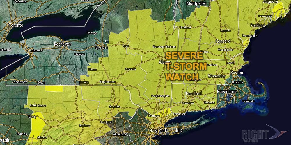
Connecticut and most of Massachusetts are under a Severe Thunderstorm Watch until 10 pm Thursday evening. An approaching cold front will combine with warm, humid air over the Northeast to trigger widespread thunderstorms Thursday afternoon and night.
The best chance of seeing severe thunderstorms is away from the coast, and the Storm Prediction Center has left RI and SE MA out of the Severe Thunderstorm Watch. Thunderstorms are still possible in RI and SE MA, but there is a lower chance that they will produce damaging winds and flooding rain. Scattered thunderstorms are popping up in interior Southern New England Thursday afternoon. An organized line of thunderstorms is likely to move through SNE Thursday night.

The following is a technical discussion from the Storm Prediction Center that discusses the scientific reasoning behind the issuance of the Severe Thunderstorm Watch.
MESOSCALE DISCUSSION 1878
   NWS STORM PREDICTION CENTER NORMAN OK
   1124 AM CDT THU SEP 12 2013

   AREAS AFFECTED...NEW ENGLAND

   CONCERNING...SEVERE POTENTIAL...WATCH POSSIBLE

   VALID 121624Z - 121730Z

   PROBABILITY OF WATCH ISSUANCE...60 PERCENT

   SUMMARY...SEVERE THUNDERSTORM WATCH MAY BE REQUIRED SOON TO ACCOUNT
   FOR ONGOING CONVECTION AND NEW DEVELOPMENT LATER THIS AFTERNOON.

   DISCUSSION...SFC TEMPERATURES ARE WARMING THROUGH THE 70S INTO THE
   LOWER 80S ACROSS MUCH OF SRN NEW ENGLAND EARLY THIS AFTERNOON AND
   RESULTANT INSTABILITY HAS INCREASED SUBSTANTIALLY ACROSS CT/MA/SERN
   NH.  CONVECTION IS RESPONDING ACCORDINGLY WITH ROBUST UPDRAFTS
   INCREASING IN INTENSITY/COVERAGE ALONG A CORRIDOR FROM THE LOWER
   HUDSON RIVER VALLEY...NEWD INTO EXTREME SRN ME.  THIS TREND IS
   EXPECTED TO CONTINUE INTO THE MID AFTERNOON HOURS AND GIVEN THE VERY
   MOIST AIRMASS...PW VALUES ON THE ORDER OF 1.75-2 INCHES...DAMAGING
   DOWNBURSTS MAY ACCOMPANY THE STRONGEST CONVECTION.  NWD EXTENT OF
   SEVERE THREAT WILL BE LIMITED BY EXTENSIVE CLOUDINESS/MORE STABLE
   CONDITIONS OVER NRN ME.


