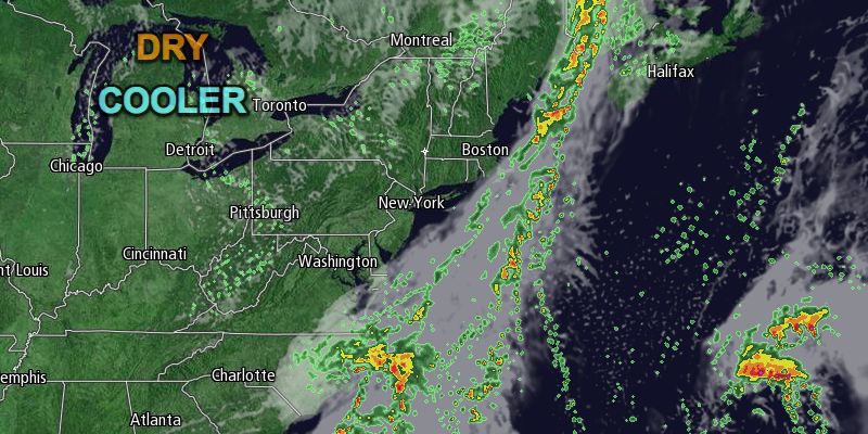
Southeastern New England squeaked out another nice day on Saturday. Clouds cleared for most of RI and SE MA in the afternoon. High temperatures reached the low to mid 70s with a gusty southerly wind. The dew point rose into the 60s ahead of a cold front that will bring showers late Saturday night through part of Sunday morning.
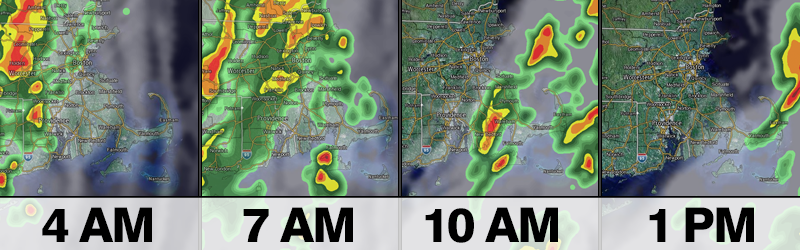
Clouds will thicken Saturday night and showers will arrive in RI and SE MA between 4-6 am and continue until 10 am – 12 pm as the line moves from west to east. There may be some heavy downpours, and a thunderstorm cannot be ruled out. It will be mild and muggy early in the day, with the temperature and dew point in the 60s. There will be a 10-20 mph southerly breeze. Most of the area will receive 0.5-1″ of rain as the cold front passes. The line of showers will move through all but Cape Cod by noon, and drier weather is ahead in the afternoon. A stray shower is possible late in the day as a disturbance swings through behind the front.
The best part of Sunday will be from noon through the late-afternoon as the sun breaks through the clouds and the temperature rises into the low to mid 70s. The wind will shift and come out of the northwest in the afternoon. The 10-15 mph breeze will usher in drier air. The dew point will fall from the mid to upper 60s early in the day to the upper 40s to low 50s by late in the day. Fall arrives at 4:44 pm EDT. The sunset will be at 6:42 pm.
More dry weather next week
Another extended stretch of dry weather is in the forecast for next week. Initially, it will be slightly cool as high pressure moves in from the west early in the week. Monday through Wednesday look partly cloudy to mainly clear with highs in the 60s and low in the 40s to low 50s. The main wind direction will be north to northeast, keeping the relatively cool air locked in. Overall, it looks like some pretty decent early fall weather.

It’s unclear if there will be a warm-up late in the workweek. It is possible that high pressure will move south of Southern New England allowing for a southwesterly wind to bring in warmer air, but it’s also possible that an offshore storm could keep the wind direction out of the northeast, and highs in the 60s through the end of the workweek. In any event, it looks dry. Looking ahead to next weekend, the temperature should climb into the low 70s with dry weather lasting through Sunday.


