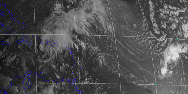
Tropical Storm Gabrielle was not long for this world. The storm formed on the evening of September 4th, and by noon on September 5th it had already weakened to a tropical depression. By the end of the day the tropical depression officially became known as “remnants” meaning it was back to where it was a few days ago – a cluster of showers and thunderstorms bringing locally heavy rain to Puerto Rico and the Virgin Islands.
Elsewhere in the tropics, a disturbance in the southwestern Gulf of Mexico is moving inland before it has a chance to develop. The storm will bring heavy rain and mudslides to Veracruz, Mexico – the same area hit by Fernand in late-August.
There is also a tropical wave 600 miles west of the Cape Verde islands that is not showing much potential. Farther down the line there is a strong tropical wave over western Africa. That is expected to hit the Atlantic Ocean in the next couple of days and has a 50% chance of becoming a tropical cyclone within five days. Most computer models curve the system out to sea in the central Atlantic Ocean.
The climatological peak of the hurricane season is September 10, and we are still awaiting the first hurricane of the year. 2013 is poised to be the first year in the satellite era without a hurricane before September 12. In 2002, Hurricane Gustav formed on September 11. In that year, there were four hurricanes, including two major hurricanes.
TROPICAL WEATHER OUTLOOK
NWS NATIONAL HURRICANE CENTER MIAMI FL
800 AM EDT FRI SEP 6 2013

FOR THE NORTH ATLANTIC...CARIBBEAN SEA AND THE GULF OF MEXICO...

1. A BROAD AREA OF LOW PRESSURE IN THE SOUTHWESTERN GULF OF MEXICO IS
APPROACHING THE COAST OF MEXICO NEAR TAMPICO....ACCOMPANIED BY A
LARGE BUT DISORGANIZED AREA OF CLOUDINESS AND A FEW SQUALLS OF
WINDS TO NEAR TROPICAL STORM FORCE.  THIS SYSTEM IS EXPECTED TO
MOVE INLAND BEFORE SIGNIFICANT DEVELOPMENT CAN OCCUR...AND IT HAS A
LOW CHANCE...20 PERCENT...OF BECOMING A TROPICAL CYCLONE DURING THE
NEXT 48 HOURS...AND A LOW CHANCE...20 PERCENT...OF BECOMING A
TROPICAL CYCLONE DURING THE NEXT 5 DAYS. HEAVY RAIN AND GUSTY WINDS
WILL BE SPREADING ALONG THE COAST OF THE MEXICAN STATES OF VERACRUZ
AND TAMAULIPAS TODAY.

2. A COMPLEX AREA OF DISTURBED WEATHER...WHICH INCLUDES THE REMNANTS OF
GABRIELLE...EXTENDS FROM THE DOMINICAN REPUBLIC AND PUERTO RICO
NORTHEASTWARD INTO THE ATLANTIC FOR SEVERAL HUNDRED MILES.  ANY
DEVELOPMENT OF THIS DISTURBANCE SHOULD BE SLOW TO OCCUR DUE TO
UNFAVORABLE UPPER-LEVEL WINDS AND THE PROXIMITY OF DRY AIR.  THIS
SYSTEM HAS A LOW CHANCE...10 PERCENT...OF BECOMING A TROPICAL
CYCLONE DURING THE NEXT 48 HOURS AS IT MOVES NORTHWESTWARD OR
NORTHWARD AT 10 TO 15 MPH. SOME DEVELOPMENT OF THIS SYSTEM IS
POSSIBLE IN A FEW DAYS WHEN THE DISTURBANCE MOVES NORTHEASTWARD
AHEAD OF A COLD FRONT OVER THE CENTRAL ATLANTIC OCEAN.  THIS
SYSTEM HAS A MEDIUM CHANCE...30 PERCENT...OF BECOMING A TROPICAL
CYCLONE DURING THE NEXT 5 DAYS.

3. A BROAD LOW PRESSURE SYSTEM ASSOCIATED WITH A TROPICAL WAVE LOCATED
ABOUT 600 MILES WEST OF THE CAPE VERDE ISLANDS IS PRODUCING
DISORGANIZED SHOWER ACTIVITY.  HOWEVER... DEVELOPMENT OF THIS
SYSTEM IS NOT LIKELY DUE TO UNFAVORABLE ENVIRONMENTAL CONDITIONS.
THIS SYSTEM HAS A LOW CHANCE...NEAR 0 PERCENT...OF BECOMING A
TROPICAL CYCLONE DURING THE NEXT 48 HOURS...AND A LOW CHANCE...NEAR
0 PERCENT...OF BECOMING A TROPICAL CYCLONE DURING THE NEXT 5 DAYS
WHILE IT MOVES TO THE WEST-NORTHWEST AT ABOUT 10 MPH.

OTHER SYSTEMS WITH FORMATION POTENTIAL BEYOND 48 HOURS...

A TROPICAL WAVE OVER WEST AFRICA IS EXPECTED TO MOVE OVER THE FAR
EASTERN ATLANTIC OCEAN IN A DAY OR TWO...AND DEVELOPMENT OF THIS
SYSTEM IS POSSIBLE LATE THIS WEEKEND INTO EARLY NEXT WEEK. THIS
SYSTEM HAS A LOW CHANCE...NEAR 0 PERCENT...OF BECOMING A TROPICAL
CYCLONE DURING THE NEXT 48 HOURS...AND A MEDIUM CHANCE...50
PERCENT...OF BECOMING A TROPICAL CYCLONE DURING THE NEXT 5 DAYS.


