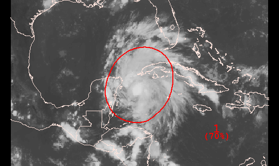
A developing area of low pressure is moving from the Western Caribbean into the Gulf of Mexico in the next 24 hours. As of 8pm Wednesday, the storm did not have a well-defined circulation, but, according to the National Hurricane Center it could become a tropical cyclone at any time. There is a 70% chance that the system becomes a tropical cyclone in the next five days.
The storm is forecast to move through the Gulf of Mexico and hit the United States somewhere along the Gulf Coast from Louisiana to the Florida Panhandle. At this point, it is not forecast to strengthen into a hurricane, but it may be a tropical storm (Karen) when it nears the U.S. Coast.
Computer model forecasts for Invest 97
TROPICAL WEATHER OUTLOOK
NWS NATIONAL HURRICANE CENTER MIAMI FL
800 PM EDT WED OCT 2 2013

AN AIR FORCE RESERVE UNIT HURRICANE HUNTER AIRCRAFT HAS EXTENSIVELY
INVESTIGATED THE BROAD AREA OF LOW PRESSURE OVER THE NORTHWESTERN
CARIBBEAN SEA...AND DETERMINED THAT THE SYSTEM DID NOT HAVE A
WELL-DEFINED CIRCULATION. HOWEVER...THE LOW IS PRODUCING WINDS TO
GALE FORCE AND HAS THE POTENTIAL TO BECOME A TROPICAL STORM AT ANY
TIME TONIGHT OR ON THURSDAY. THE LOW IS EXPECTED TO MOVE NORTH-
NORTHWESTWARD NEAR OR OVER THE NORTHEASTERN PORTION OF THE YUCATAN
PENINSULA THIS EVENING...AND INTO THE SOUTHERN GULF OF MEXICO BY
EARLY THURSDAY. THIS SYSTEM HAS A HIGH CHANCE...70 PERCENT...OF
BECOMING A TROPICAL CYCLONE DURING THE NEXT 48 HOURS. AFTER
THAT...STRONG UPPER-LEVEL WINDS ARE LIKELY TO LIMIT DEVELOPMENT AS
THE SYSTEM APPROACHES THE NORTHERN GULF OF MEXICO BY THE WEEKEND.
THIS SYSTEM HAS A HIGH CHANCE...70 PERCENT...OF BECOMING A TROPICAL
CYCLONE DURING THE NEXT 5 DAYS. LOCALLY HEAVY RAINS COULD AFFECT
THE CAYMAN ISLANDS...PORTIONS OF CUBA...AND PORTIONS OF THE YUCATAN
PENINSULA DURING THE NEXT DAY OR TWO. INTERESTS IN THE NORTHEASTERN
YUCATAN PENINSULA...WESTERN CUBA...AND THE NORTHERN COAST OF THE
GULF OF MEXICO SHOULD MONITOR THE PROGRESS OF THIS SYSTEM.


