Monday was the seconds straight bitter cold day in Southern New England. Highs were only in the low to mid 30s after starting the day in the teens – for many the coldest morning since mid-February. Monday night will not be as chilly as Sunday night, with clear skies giving way to some late clouds, and lows in the mid to upper 20s. The temperature will fall quickly in the evening, then hold steady after midnight.
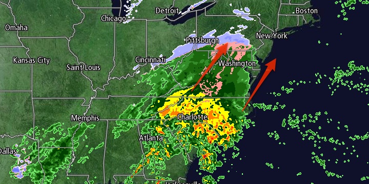
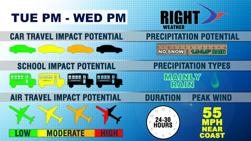
Clouds will thicken on Tuesday as a large storm begins to move up the East Coast. Heavy rain may cause travel delays at airports in the Southeast and Mid-Atlantic on Tuesday. The rain will hold off until late in the day or Tuesday evening in Southern New England. Highs will be in the low to mid 40s with the wind shifting from the southwest to east late in the day. It will not be as breezy as Monday.

Rain will become steady Tuesday night, and it may be heavy by dawn Wednesday. The wind will increase out of the south to 20-35 mph by dawn, and the potential exists for higher gusts. A High Wind Watch has been posted by the National Weather Service for the possibility of 55 mph gusts. The temperature will rise through the 40s into the mid to upper 50s by dawn Wednesday.
Travel in the Northeast will be affected by the storm on Wednesday. At airports, combined strong wind and heavy rain could lead to delays. On the roads, moderate to heavy rain is likely Wednesday morning from Philadelphia to Boston. The rain and strong winds combined with increased traffic volume before Thanksgiving will make for slow commutes. Rain and strong winds will continue throughout Wednesday in Southern New England. It will be unseasonably warm, with the temperature jumping into the low 60s in most of RI and SE MA.
Rain will wind down Wednesday evening as the storm moves north of Southern New England. Colder air will quickly return on a gusty westerly wind late Wednesday night. A few snow showers or flurries are possible late at night, but no accumulation is expected. The temperature will drop from the 50s Wednesday evening to the upper 20s to low 30s by dawn on Thanksgiving. Thanksgiving looks blustery and cold. Highs will only be in the low to mid 30s with partly to mostly cloudy skies and a 15-35 mph westerly wind.
It will be very cold Thursday night as skies clear and the temperature drops into the upper teens to low 20s by early Friday morning. The early bird shoppers will feel wind chills in the single digits to low teens. Friday afternoon looks sunny and chilly, with highs in the mid 30s. The weekend will be mainly dry and cool. Saturday should be mostly sunny with highs in the mid to upper 30s. Sunday will become mostly cloudy with the chance of rain showers late in the day. Highs will be in the low 40s.


