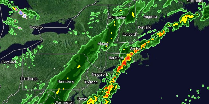
Wednesday was a rather nice mid-fall day in Southern New England. The temperature flirted with 60° in the early to mid afternoon under mostly sunny skies. Clouds rolled in from the west late in the day. An onshore breeze made it feel a bit cooler near the coast. The wind will continue to be out of the south Wednesday night as a cold front moves into the Northeast. The temperature will fall into the low to mid 50s with increasing clouds. Patchy drizzle and mist is possible near the coast after midnight. Showers may develop by dawn. The wind will increase to 10-25 mph by dawn. The breeze will be strongest near the coast.
Thursday will be breezy and mild with occasional showers. Highs will be in the low 60s. The wind will shift from the southwest to northwest during the afternoon. Rain will end by late in the day, and skies will clear Thursday night. The temperature will drop into the mid 30s to low 40s by dawn Friday. Friday looks partly cloudy, brisk and cooler, with highs in the upper 40s to low 50s.

The weekend will be quiet and cool. Saturday will be the colder day, with lows in the 20s to low 30s and highs in the mid to upper 40s under mostly sunny skies. A weak disturbance will move through Northern New England Saturday night into Sunday. That will help to bring in slightly warmer weather for Sunday. It should be a partly cloudy, breezy day with highs in the low to mid 50s.
Monday will be a dry and seasonable day. You can expect sun and clouds with highs in the low 50s. A cold front will move through New England Monday night, and behind it will be some very chilly weather. Tuesday looks dry with highs in the 40s. The colder air settles in on Wednesday. We’ll be watching a storm evolve in the Ohio Valley in the middle of next week. Right now, the forecast is for dry, cold weather on Wednesday. Lows will be in the 20s, and highs may struggle to reach 40°! If the storm develops quickly and a little farther north than expected, then there may be some cold rain, snow or mixed precipitation in Southern New England Wednesday into Thursday.


