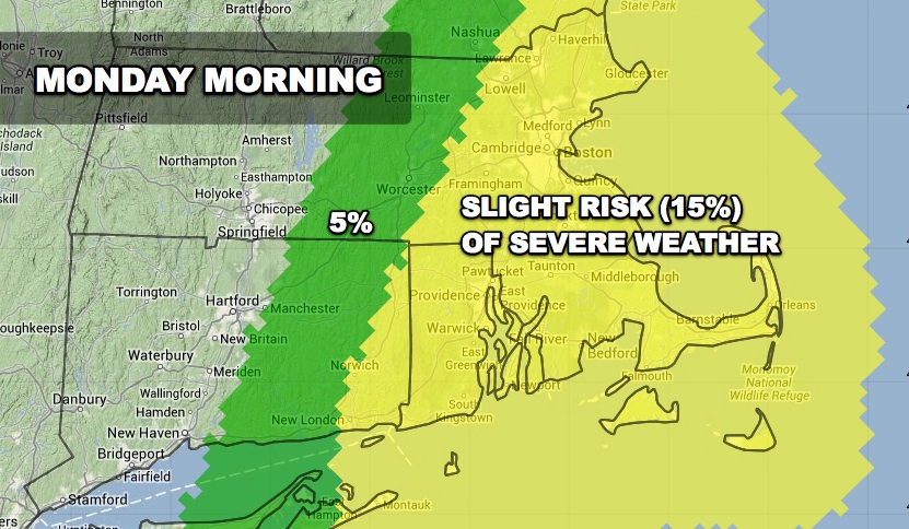
A vigorous storm system that has produced tornadoes in the Midwest will move through New England late Sunday night into Monday morning. Tornadoes are not a threat for Southern New England, but the potential exists for damaging wind gusts in any heavy showers early Monday morning. The Storm Prediction Center has placed Southeastern New England in a 15% risk of severe weather – primarily strong winds of 58 mph or greater. The primary storm threat is from 5 am to 11 am from west to east in New England.


 DAY 2 CONVECTIVE OUTLOOK
   NWS STORM PREDICTION CENTER NORMAN OK
   1057 AM CST SUN NOV 17 2013

   VALID 181200Z - 191200Z

   ...THERE IS A SLGT RISK OF SVR TSTMS OVER SRN NEW ENGLAND MONDAY
   MORNING...

   ...SYNOPSIS...
   INTENSE NEGATIVELY TILTED SHORT WAVE TROUGH IS FORECAST TO LIFT
   RAPIDLY NEWD ACROSS NEW ENGLAND AND QUEBEC EARLY IN THE DAY 2 PERIOD
   IN ASSOCIATION WITH A VERY STRONG MID/UPPER LEVEL JET STREAK
   TRANSLATING ACROSS THE REGION.  AT THE SURFACE...A DEEP LOW WILL
   MOVE NEWD INTO QUEBEC WITH A COLD FRONT ARCING SWD FROM THE LOW.
   THE FRONT WILL MOVE RAPIDLY EWD ACROSS CENTRAL ME AND SRN NEW
   ENGLAND BY EARLY AFTERNOON...CONTINUING SEWD/SWD OFF THE SOUTHERN
   ATLANTIC COAST AND GULF COAST DURING THE AFTERNOON.

   ...PARTS OF SRN NEW ENGLAND...
   SUFFICIENT LOW LEVEL MOISTURE WITH SURFACE DEW POINTS OF 55-60F WILL
   SPREAD NWD INTO PARTS OF SRN NEW ENGLAND AHEAD OF THE ADVANCING COLD
   FRONT.  DESPITE LIMITED BUOYANCY...FORCED ASCENT ALONG THE FRONT IS
   EXPECTED TO MAINTAIN POTENTIAL FOR A LOW-TOPPED SQUALL LINE WITH
   EMBEDDED BOW ECHOES INTO THE MORNING OVER ERN PARTS OF SRN NEW
   ENGLAND.  ALTHOUGH IT IS UNCLEAR IF MUCH LIGHTNING WILL BE GENERATED
   WITHIN THE LINEAR CONVECTIVE SYSTEM...VERY STRONG LOW LEVEL WINDS
   /60-70 KT WITHIN THE LOWEST 1-3 KM AGL/ INDICATE POTENTIAL FOR
   DAMAGING WINDS TO OCCUR FOR A FEW HOURS DURING THE MORNING BEFORE
   THE CONVECTIVE SYSTEM MOVES OFFSHORE.

   ..WEISS.. 11/17/2013


