There will be no rest for the weary as the pre-winter cold snap continues into the workweek, with more snow in the forecast for Tuesday. The storm that brought several inches of snow followed by rain Saturday night, and strong winds near the coast Sunday morning, moved away from Southern New England on Sunday.
- Southern New England snow totals December 14-15, 2013
- Southern New England peak wind gusts December 15, 2013
The temperature which hovered in the 20s to low 30s all day, will drop into the teens to low 20s by dawn Monday. There will be refreezing of slush and puddles, so watch your step in the morning. The wind will be active out of the west at 10-20 mph late tonight, and wind chills in the morning will be in the upper single digits to low teens. It will not warm up much on Tuesday. Look for mostly sunny skies with highs in the mid 20s and wind chills in the teens thanks to a 15-30 mph breeze.

It will be mainly clear and very cold Monday evening. Clouds will stream in ahead of a developing storm late Monday night. The temperature will range from the upper single digits to upper teens by dawn on Tuesday. Snow will develop Tuesday morning, and it may be steady during the afternoon. It’s a dynamic situation with a developing storm over or south of Southern New England. The snow forecast is a bit unclear because of the uncertainty with exactly where the storm will develop. It looks like a light to moderate event for most of Southern New England. Snow will continue Tuesday afternoon before tapering to snow showers and flurries Tuesday night.
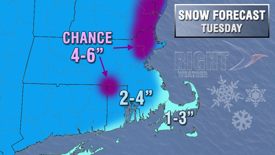
Tuesday’s temperatures will be highly contingent on where the storm develops. It will likely stay very cold inland, with milder air, possibly in the low 30s, reaching the coast. The cold air will return Tuesday night to all of Southern New England, and lows Wednesday morning will be in the teens – with wind chills in the single digits.
The mid to late workweek weather should be fairly quiet with a gradual warming trend. Highs will range from the mid 30s Wednesday to near 40 Thursday and in the 40s on Friday. Wednesday and Thursday looks mostly sunny. Friday will become partly to mostly cloudy. Rain showers are possible at the start of next weekend, with the weather turning colder on Sunday.
Snowy owl in Rhode Island photo courtesy of 02809photo.com


