
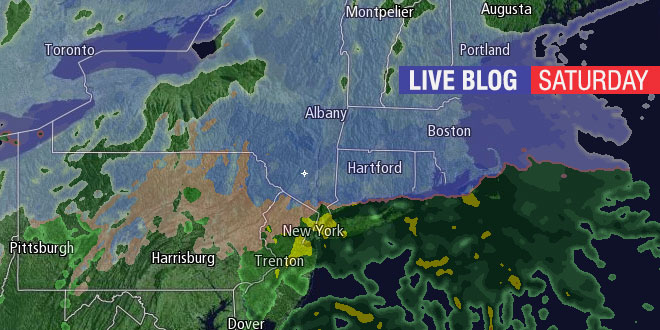
A significant winter storm will deliver snow, sleet, and rain to Southern New England. Check this page often for live blog updates from Right Weather meteorologist Fred Campagna on Saturday, December 14, 2013. Feel free to ask questions in the comment section near the bottom of the page.
- Download the FREE RightWX app for your Android or iOS device
- Check the Interactive Radar here
- Click here: http://goo.gl/lnPg8K to view the updates on your iOS device (Android users may need to visit rightweather.com)
Fred. When do you expect the bulk of the precip to be over? Also when do you think the mix/change will take place in the PVD area?
Answered above in live blog.
Fred,
How do you think the roads will be tonight in Smithfield around 10pm?? Is the majority of the precipitation come after then?
Answered above in live blog.
We’ve been having flurries in Middletown since about noon.
Do you think what ever snow falls will be washed away after the change to rain?
Fred, would you happen to know the snow to rain ratio with this storm?
Answered in the live blog.
Fred, I think we should come up with an acronym for these types of storms: H.A.S. (Heart Attack Snow) event!
For us older folk and those that have heart issues!! But common sense should prevail!!
Hi Fred – it looks like temperatures were a couple of degrees cooler today in RI / SE MA than what the models forecasted. Is that something that will affect the expected mixing of rain/sleet/slow overnight and tomorrow morning?
Fred- is there a chance the changeover to rain comes sooner, making totals smaller?
Thanks for dropping the 6-9″ line into West Warwick Fred 😉 I know one thing. I’ll be out there clearing it before any rain soaks into it.
I knew that would make you happy. Now, I just hope it verifies! All the short-range modeling shows the cold air hanging on for a while in your part of the state. I’ve seen it before.
Hourly temperature change rate went from negative to positive about 5:45 P.M. here in Woonsocket, RI.
Thanks for the report, Arthur!
Just signed up today. You are doing a super fine job with these updates.
Thanks for joining Right Weather Pro!
3-5 now wth!
What are you referring to?
ok fred call me crazy but with a easterly wind in eastern mass,and a north and northeast wind can we see a conversition setting up ?
Was that supposed to read “coastal front”?
that is correct fred .
Yes, we were expecting the coastal front. The highest totals will be northwest of the front.
total snowfall forecast seeing 3-5 for ri
Are you referring to our forecast?
Temps are definitely on the rise here at Camp Fuller. We’re at 24. The wind is really pushing the snow that’s falling so we can’t tell what kind of accumulation we’re actually getting. Coming down a bit heavier now though.
Thanks for the update!
Is the lull, just that, a lull or a sign of a weakening storm (i.e. ending quicker/less accumulation)
3.0″ in West Warwick Fred at 10pm. 25.5 degrees
What is the time-frame for the re-freeze Sunday afternoon/night? Before sunset or in the evening?
Fred – It sounds like the winds are picking up outside where I am in Tiverton (near the Little Compton and Westport lines), should we anticipate the strong winds to be from the NE only ? Or will they eventually come around to the SE by tomorrow morning? Thanks, Brendan
At 10:00 PM 4″ of snow on the ground in Chepachet. The NWS said we would have 2-4 inches by 3:00 AM!!!
Temp is 18 in Chepachet!
Riverside: 30 deg. Light Snow, mixing with sleet & rain, wind picking up from the SSE. About 3″ total so far!!
At Woonsocket snowfall at 12 M was exactly 4.0 inches.
Melted precip was .34 in.
Temp up from 19 at 10 PM to 27 at 12 M
Out wind just a bit North of East
Thanks!
Steady plain rain started at 1230am down here at the Tiverton/Little Compton line. Just about 5 inches of fluffy snow totaled up before the changeover.
just before 3AM, West Glocester, turning to sleet. just about 6 inches of snow on the ground. great forecast!
All rain in Woonsocket since 3:15 AM
7 AM Totals for Woonsocket
Snowfall 5.7 in.
Precip 0.92 in.