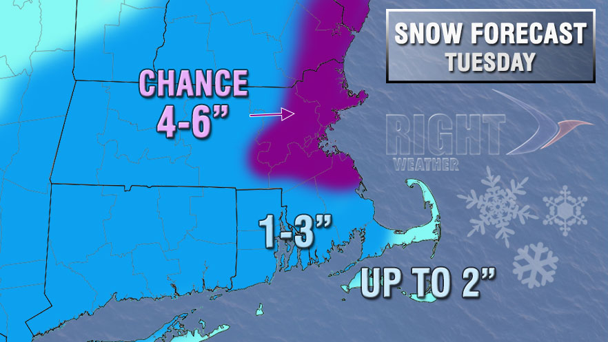
Our latest snowfall accumulation map has anywhere between 1-6″ of snow in the forecast for Tuesday in Southern New England. Most of the area is in a 1-3″ range, with the potential for a bit less on Cape Cod, and a few more inches are possible in Eastern MA north of Plymouth. Hopefully, after looking at the charts and reading below, you will have a better idea of the method to the madness we use when creating our forecast.
The charts below are valid for all of RI and Bristol/Plymouth Counties in MA


After looking at these charts and then the snow map you may be wondering why we have a low-end of 1″ if we’re fairly confident in at least 2″. The reason for the 1″ low-end is that we are not dealing with a lot of moisture, and if the storm goes in fits and starts instead of staying steady for a few hours, then there could be a measly inch in some spots. Right now, central CT looks like the favored area for that to happen.
You may also be wondering why we have a high-end of only 3″ for the area if the outside chance of half a foot exists. It’s tricky for us because we cannot give a forecast of 1-5″ for most of Southern New England, and we’re not a big fan of 2-5″, either, because of big difference between how 2″ and 5″ would impact travel, etc. We settled on 1-3″ because we’re most confident in 2-3″ for most of the area, and we also know there is still some bust potential if the storm takes its time getting organized and does not really blossom until the moisture is north of RI and SE MA.
If anything, I think you will see this forecast trend snowier as we get a look at the developing storm early tomorrow. There is also a fluff factor to consider. It’s possible that the very cold air will get locked into RI (especially NW) and that could mean snow ratios of 20:1 instead of 10:1 or 12:1. If there’s a 20:1 snow ratio, then 0.3″ of liquid will produce 6″ of snow. Most models do not have 0.3″ of liquid in Northern RI, but with fluffy snow, a model error of just 0.1″ can mean a couple of inches of snow.


