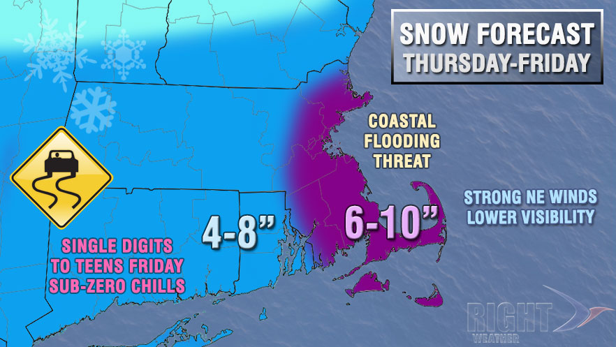
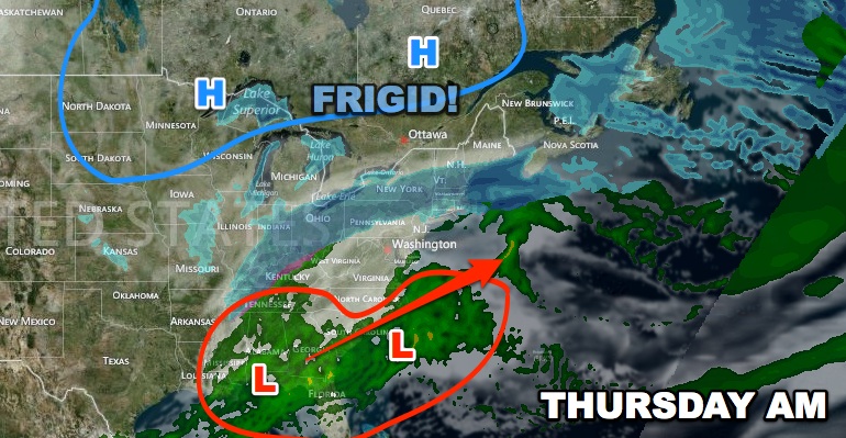
It will be a dynamic start to 2014 weather-wise in the Eastern United States. Combined Arctic air and a jet stream disturbance will lead to widespread snow in the Mid-Atlantic and Northeast Thursday into Friday. It’s a complex setup, and the forecast is not extremely high-confidence, but it looks like Southern New England will pick up a plowable snow between early Thursday and midday Friday.
It will be plenty cold enough for snow, with the temperature during the storm ranging from the teens inland to 20s near the coast on Thursday, and single digits to teens on Friday. The snow will be fluffy and wind-blown with 30+ mph gusts likely near the coast Thursday night into Friday.

Light snow will break out early Thursday, possibly before dawn, and continue on and off through the day. The steadiest snow Thursday afternoon may be north of Providence towards the MA Pike and Boston. The wind will gradually increase on Thursday as a storm strengthens in the Atlantic Ocean. Right now, it looks like the storm will be just far enough offshore that Southern New England is spared the brunt of the storm. There is still time for the storm track to shift closer to the coast allowing for a bigger impact – especially in coastal areas.
Coastal flooding is likely along the Eastern Massachusetts coastline. Tides are astronomically high, and the a couple of high tide cycles will likely occur during of strong winds and rough seas. Minor to moderate flooding is expected between midday Thursday and midday Friday.
Snow will continue Thursday night before ending Friday morning. Frigid air will charge in on a northerly wind behind the storm. The temperature will fall through the teens into the single digits then possibly below zero Friday night. The wind chill will be well below zero.
This is a dynamic situation, and the forecast may change in the next couple of days.
- Check rightweather.com for the latest.
- Follow us on Facebook, Twitter, and Google+.
- You can also download the free RightWX app for the latest updates on the forecast.
- If you are interested in more in-depth coverage, join Right Weather Pro for just $33.99/year. This is a limited-time New Year’s special of 15% off the normal price.
- If your business is highly weather-dependent, you may want to consider our Private Forecasting Service to help ease the stress of difficult forecasts and allow you to run your business efficiently in a cost-effective way.
- Our Detailed Snow Reports are perfect for snow removal contractors or property managers who want accurate and detailed storm reports for multiple zip codes


