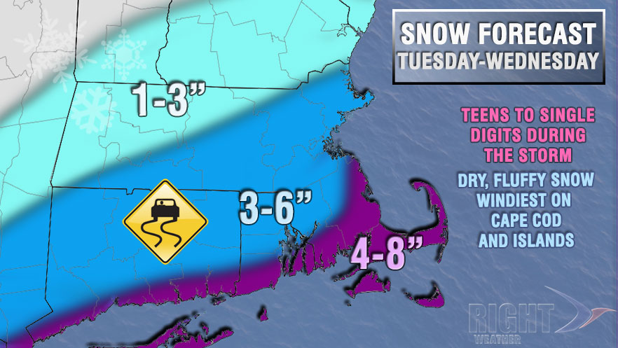
The colder, potentially active weather pattern that we have told Right Weather Pro members about for weeks is on the doorstep of Southern New England. The January thaw will end Monday night as an Arctic cold front passes and colder weather arrives by Tuesday morning. At the same time, jet stream energy will be riding through the Ohio Valley to the Mid-Atlantic coast. That energy will lead to a developing storm on Tuesday that will likely pass close enough to Southern New England to bring a period of light to moderate snow mainly Tuesday night. The National Weather Service has issued a Winter Storm Watch for coastal Southern New England.

Clouds will thicken on Tuesday, and highs will only be in the upper teens to low 20s. Snow will develop from southwest to northeast through New England Tuesday afternoon into Tuesday evening. The flakes are expected to reach the Providence metro area in time for the evening commute. The steadiest snow is likely Tuesday night near the coast. It will be very cold during the storm with the temperature falling into the low to mid teens. The wind will pick up to 10-20 mph inland, and 15-35 mph near the coast.
Snow will taper to flurries by mid-morning Wednesday then end before noon. It will be blustery and very cold, with the temperature rising from the single digits to low teens to the mid to upper teens in the afternoon.


