AnalysisMobile

Live Blog: January 2, 2014

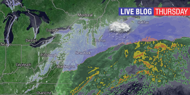
A large snowstorm will affect millions in the Northeast Thursday into Friday. The snow will likely be light during the day Thursday, but should pick up Thursday night. Check this page often for live blog updates from Right Weather meteorologist Fred Campagna. Feel free to ask questions in the comment section near the bottom of the page.


Fred Campagna

President and Chief Meteorologist - Right Weather LLC AMS Certified Consulting Meteorologist #756 AMS Certified Broadcast Meteorologist #126

Related Articles

40 Comments

  1. Hi Fred, are you expecting much of an impact on this evenings commute? I’ll be driving from Framingham to Riverside. Thanks!

  2. Fred, I’m thinking the blizzard warning will be extended west by the end of the day..what do you think?

  3. Fred – when do you think that this all moves out of here on Friday – by noon? Also, after the snow has fallen, what will be the prevailing wind direction, NE, to N to NW as Friday progresses? Just have to figure out which drifts I will be dealing with!

  4. Fred, I do not see any precip to the south of us. Can you tell where PFR is going to begin? Do you use ocean buoys when storms form far out at sea? I have a gut feeling this is not going to be as bad as first thought.

    Arctic cold still appears to be to our north and show no signs of advancing southward. Southern flow from south appears to be staying south with jet stream. Looks like moisture from south not hooking up with northern energy coming down..

    Your thoughts?

  5. The storm seems to be phasing much sooner, as seen on the radar, than thought by many of the model runs…

    1. Hi Arthur, if you have a temperature available could you put that in with your snow totals? Thank you Steve from Riverside, (formerly a Cumberland native).

  6. Hi Fred,
    What are the chances of flying into Providence tomorrow night, Friday, around midnight?
    Thanks for your time.

  7. Fred, Is the forecast still on track for 7-11″? Trying to make the final decision on whether to call Friday work off, or not…most of my staff is from SK/NK…Thanks!

  8. Well Fred looks like the Blizzard Warning has been expanded…but I agree I think it still will be growing to our west…Bristol County and in the Boston area.

  9. Fred, WJAR has changed their snowfall map, showing much lower totals for the Newport area. What is your take on this?

  10. Are you still expecting an increase in the snowfall along the southcoast overnight?

  11. Fred, I get out of work at 10pm in Lincoln and live in Charlestown. I have to be back in Lincoln at 8am tomorrow morning. So far it doesn’t look too bad out, should I stay up here or brave the drive home? How much worse and how fast will it really get?

    1. It will be a slow ride. Snow coming down and the temperature near 5° in Lincoln. Snowing all the way to Charlestown, with temps in the teens. Not a very heavy snow, but the roads will be snow-covered. Windy, too.

      1. Made it home in an 1hr 30mins, usually takes an hour. Roads were drive-able, but not plowed. Visibility was ok, significantly worse in Charlestown as the wind kicked up.

  12. Fred. Do you anticipate better snow growth as we head deeper into the storm? 1.7″ in WW

  13. 7 p.m. snowfall total for Woonsocket was 1.8. Temp then was 7 degrees and is now down to 5 degrees. Snow dramatically increased about 30 mins. ago.

  14. Fred for safe Ice questions: DEM’s 24-hour ice safety hotline at 401- 222-2632

    Steve

  15. 7 a.m. Snowfall total for Woonsocket was 7.5 in. and the temperature was 3 degrees.

      1. I cannot and my records go back to 1957. Only short term snow falling with such severe temps. In that sense I consider this event historic.

          1. 01/16/2004 (-11). Tied with 01/23/1961 for third place. Second place goes to 01/22/1984 (-15). And our all time champion belongs to 01/22/1961 (-17).

Back to top button