ArchiveForecast

Live Blog: Tuesday, January 21, 2014

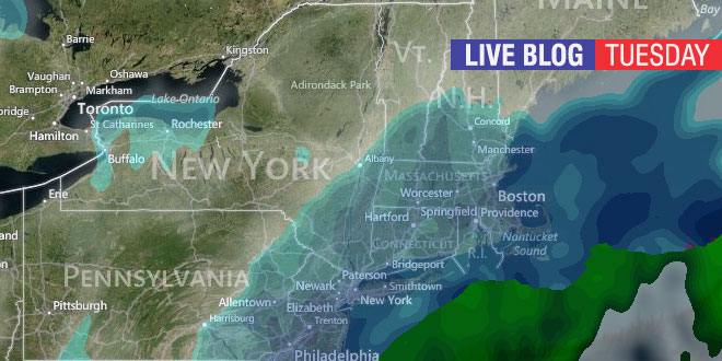
A significant snowstorm is heading for Southern New England beginning Tuesday PM and ending Wednesday AM. Check this page on Tuesday, January 22, 2014 often for live blog updates on the current weather and forecast from Right Weather meteorologist Fred Campagna. Feel free to ask questions in the comment section near the bottom of the page.

THIS BLOG IS CLOSED

Click here for the NEW LIVE BLOG

Fred Campagna

President and Chief Meteorologist - Right Weather LLC AMS Certified Consulting Meteorologist #756 AMS Certified Broadcast Meteorologist #126

Related Articles

25 Comments

  1. Good Morning Fred! So happy to have a storm that doesn’t leave us southern RI coastal people out. I really appreciate and enjoy the live blogs. Great way to stay updated.

  2. Ha ha .. Glad this storm will not be a “blockbuster”.. Since, I live in No. RI the storms usually are.. 🙂

  3. Fred, It appears the snow may be moving in faster than previously thought. Do you think it will move out faster? Or could it be a bit longer in total duration?

  4. Fred I enjoyed hearing your version on WPRO a short time ago and comparing it to Elliot Abrams version an hour earlier. Abrams needs to check his map of CT.

  5. Hi Fred! Now that is is already snowing at 11:30am (Dartmouth MA) should we be expecting the heavy stuff sooner than 4pm?

  6. Hi Fred! What are you thinking in terms of the morning commute? Any changes from previous thoughts?

  7. Fred, your latest accumulation map and update stated that there could be 12+ by the coast. Does that include the coast of RI now??? Or just Cape and Islands? We are in North Tiverton, and my kids are excited. 🙂

      1. I get too excited about snow, and my eyes start deceiving me. Thanks for keeping us all updated Fred! Enjoy the storm! 🙂

  8. I know you don’t pay attention to other stations forecasts but channel 12 really bumped up their #s in the last hour… 10-14 for most of RI and more on the outer cape… snow is coming down heavy here in Westerly but I’d be really surprised if we exceeded 10-12, we hardly ever do! We are usually victims of that ugly dry slot lol

  9. Hi Fred, Thanks for all this great info. I was wondering if you anticipate any power outages? I sincerely hope not, but better prepared than not. Thanks. I’m in the Little Compton area if that helps to narrow the scope a bit.

  10. Going from west Greenwich to Warwick for work. Need to be there for 9. Better orfleaving now or wait until traffic goes down but snow picks up?

  11. wind tonight? other channels are stating 45-50 mph gusts…i dont see that happening…YET thoughts?…

  12. Fred, trying to figure out the morning, travel and daycare. We live in Coventry and usually leave by 630am. Worth waking up to shovel at five or planning to work from home for a few hours before shoveling. Curious if there is still going to be a burst of snow at the end of the storm or when it is going to taper off. Thanks.

  13. I got 6 inches so far as of 7PM, West Glocester. Do you think we are getting more than originally forecast? Seems that way!

  14. 7 p.m. measurement in Woonsocket is 5.6 inches. With a water content of only 0.14 or an incredible ratio of 4 to 1! Hollywood sound stage type snow.!

Back to top button