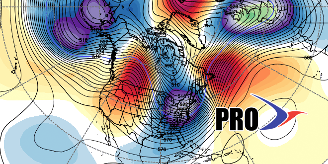
This is shaping up to be a very interesting couple of weeks in the Northeast. In fact, if some of the computer models are right, the pre-game hype for the Super Bowl will be even more nauseating than usual because New York will be in a deep freeze with the threat of snow in the week leading up to the game. The bottom-line is a mean long wave trough is returning to the Eastern United States for the last two weeks of the month. While there is no guarantee of snow, the pattern favors cold weather in the Northeast. If the storm track sets up just offshore, there could be several bouts of snow. If it’s a little farther offshore, it will be my least favorite kind of weather – cold and dry.
At this point, it’s too early to say how much weather action there will be, but it’s a pattern that will have us eagerly anticipating the medium to long-range computer model runs. You can see what a tricky pattern it is by the forecast for later this week. Here we are on Monday evening, and there is uncertainty about how a couple of systems will evolve on Thursday and Saturday. This is definitely a “playing with fire” kind of pattern. If the storms develop too late, we don’t get burned. If they develop a little closer to the coast, we get snow, and if they develop too near the coast, rain is still in play. My feeling is that the pattern evolution in the next five days will give us a better glimpse into the rest of January. Hopefully, we’re not sitting here next Monday wondering what will happen next Thursday and Saturday. Check out the video for more.


