Everyone knows the Super Bowl is this weekend, but meteorologists in the Northeast could have multiple “Super Bowls” in the next few weeks. On of the many former news directors at channel 6 used to refer to the big weather events as “Super Bowls” for the weather team. So far this winter, the early January storm is probably the only one that was “Super Bowl” worthy. A very active weather pattern unfolding from coast to coast in the next couple of weeks could bring moisture-laden winter storms to the Mid-Atlantic and Northeast.
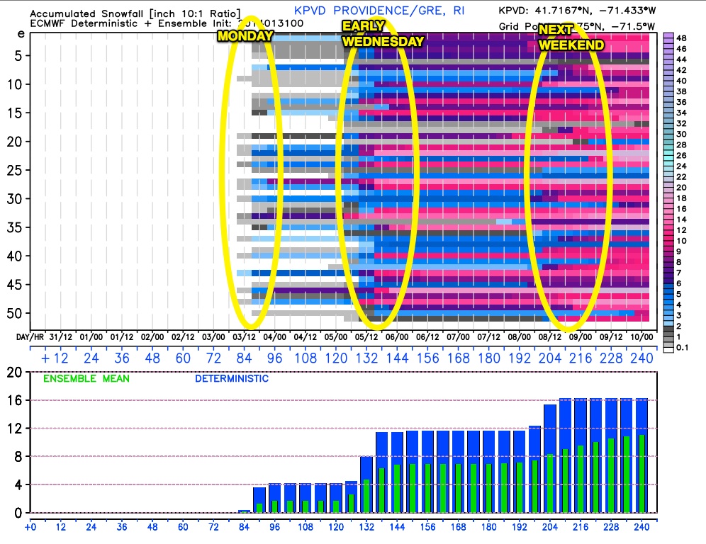
We’re not writing off the possibility of light snow on Monday in Southern New England. It looks like the models are keeping the storm riding along a cold front from the Southeast to the Mid-Atlantic too far south. We’ll continue to track it over the weekend. At this point, I think it’s 50/50 that it gets far enough north to clip SNE with a bit of snow on Monday.
A bigger ticket storm is likely to arrive Tuesday night into Wednesday. The setup is certainly not ideal for all snow in Southern New England, but there could be several hours of snow or mixed precipitation before a change to rain. The timing of the storm is not great for the Wednesday morning commute. Right now, it looks like the thump of snow/ice would happen late Tuesday night, and it may still be wintry at dawn on Wednesday. It’s too early to put up a snow map. The big question at this point is whether there will be enough cold air for snow at the start or are we looking at mainly sleet and freezing rain before a change to rain. We think there will be snow accumulation, especially northwest of I-95.
Normally, we’re not too gung-ho on a 8-10 day forecast, but the pattern is showing strong signs of another storm next weekend. While we cannot talk specifics, there is a much higher than normal likelihood of precipitation next weekend, and the overall pattern favors at least part of it being wintry. Looking further down the road, the active jet stream pattern continues, with more significant weather events possible through mid-February.
The bottom-line is there will be several chances to add to the snow totals in Southern New England during the first two-plus weeks of February. In Southern New England, there is a relatively fine line between a 12″ snowstorm and 2″ of snow followed by an inch of rain. The pattern we’ve been in for the past 10 days or so was “boom or bust” for snow because any storms that could get far enough north in the cold air were highly likely to bring exclusively snow. The upcoming pattern is also boom or bust because the storm track is critical. An inland track kills the snow potential in Southeastern New England. So, with the pattern that’s just wrapped up we had the cold air, but weren’t sure about the extent of the storminess. The upcoming pattern will have plenty of storms, but the extent of cold air, and more precisely the storm track, is questionable.


