Right Weather Pro

Pro Update: Late-January analog years

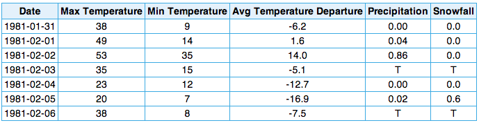
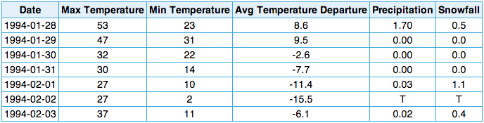
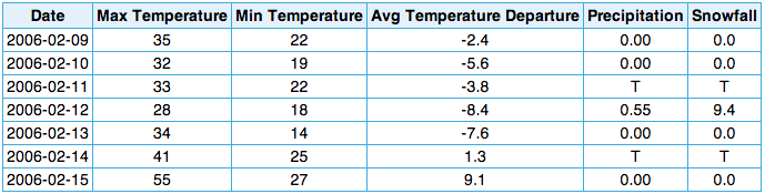
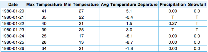
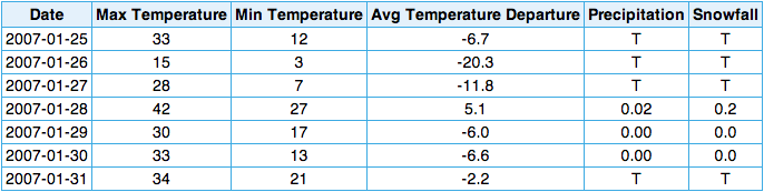
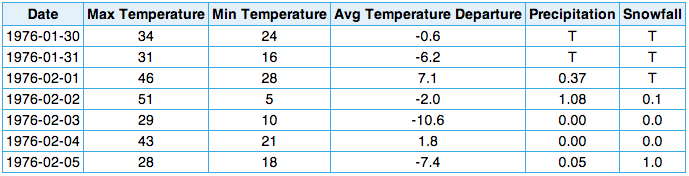
The NOAA Climate Prediction Center offers a daily look at the top analog weather patterns for the 8-14 and 6-10 day forecast. The top-10 analogs are listed on the graphic. Of course, those dates do not mean anything unless you know what the weather was like when the jet stream pattern was similar to what is forecast. We went back and looked at the weather in Providence, RI during the week around the top-10 analog dates for the current forecast centered on January 26, 2014. See the graphics below.

814analog.off

February-8-1995
February 8, 1995 – the top analog year featured plenty of cold weather, but only a trace of snow.
February-2-2007
February 2, 2007 – Once again, some cold weather, but not much snow. Not pictured here, but it stayed mostly cold through Feb. 19
February-3-1981
February 3, 1981 – It went from mild to cold, and there was only 1″ of snow.
January 15, 2009 - Weather shifted from cold to colder, with a snowstorm on January 18 that produced nearly 8" of snow.
January 15, 2009 – Weather shifted from cold to colder, with a snowstorm on Jan 18 that produced nearly 8″ of snow.
january-31-1994
January 31, 1994 – Mild to cold pattern, with a 1.5 inches of snow. Further down the road, between Feb 8-11, there was 17″ of snow. The coming cold pattern will probably last into early February.
february-12-2006
February 12, 2006 – One of the milder analog years, but also the snowiest, with 9.4″ of snow on February 12.
january-23-1980
January 23, 1980 – Chilly, but not extremely cold. It eventually got colder, but still not snow, in early February.
january-28-2007
January 28, 2007 – ’07 again, this time a few days earlier than the second analog in this list. Cold, but not snowy.
january-21-2009
January 21, 2009 – ’09 again, nearly a week later than the first analog.
february-2-1976
February 2, 1976 – Pattern shifted colder on February 5. 3.5″ of snow from February 5-6.

What does all this mean?

How much can we learn from all of this? While it’s not going to tell us too much about the specific weather that will happen in New England in the last week of January, we can definitely get an idea about what is coming our way. The bottom-line is the pattern almost always leads to a significant cold shot, but not always a lot of snow. The top-five analog years all featured at least one day when the temperature was more than 15° colder than normal. However, only one of the top-5 years had a snowstorm within three days of the analog date.

The long-range computer models are showing not just the cold shot, but also the potential for snowy weather during the week of January 26. We are highly confident in the cold forecast. The snow, however, is much harder to predict in the 8-14 day range. As we’ve mentioned in the Long Range forecast, it’s a high potential pattern.

Fred Campagna

President and Chief Meteorologist - Right Weather LLC AMS Certified Consulting Meteorologist #756 AMS Certified Broadcast Meteorologist #126

Related Articles

Back to top button