WED AM UPDATE
The snow event is on schedule in Southern New England. The highest accumulation will likely be on Cape Cod or Nantucket, where isolated 6″ fluffy snow totals are possible. Most of RI and interior SE MA will see 1-2″ of snow, ending between 8-9 am.
Look for increasing sunshine with highs in the low to mid 20s on Wednesday afternoon.
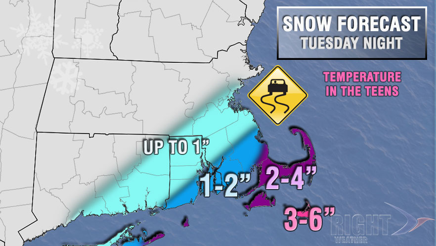
TUESDAY EVENING UPDATE
A storm will brush by Southern New England Tuesday night into early Wednesday morning spreading light snow in Southeastern Massachusetts and part of RI. The best chance of several inches of snow is on Nantucket, with a few inches also possible on Cape Cod. A Winter Weather Advisory was issued by the National Weather Service. Most of Southern RI and coastal SE MA will receive 1-2″ of light, fluffy snow between 12 am – 9 am Wednesday.

It should stay dry through the evening, with a few hours of snow occurring sometime between midnight and 8 am in RI, and 1 am – 10 am in SE MA. Snow may liner until midday on Nantucket. The temperature will be in the teens Tuesday night, and climb into the mid 20s on Wednesday afternoon after the snow ends.
Rare big winter storm in the Deep South will brush by SNE tonight with light snow. Radar: http://t.co/2NJyL4XLQv pic.twitter.com/CkwEvpXHax
— Right Weather (@RightWeather) January 28, 2014
The storm responsible for the snow was bringing wintry weather well into the Deep South on Tuesday. Travel was treacherous in areas that do not normally receive several inches of snow. The center of the storm will pass well south of Nantucket, but the northern edge of the snow should come close enough to clip Southeastern New England.
@spann Asheville road in Leeds,very icy pic.twitter.com/SkXP8MVthc
— Nicole D. Braswell (@nicole_braswell) January 28, 2014


