TV Station snow forecast roundup – January 1, 2014

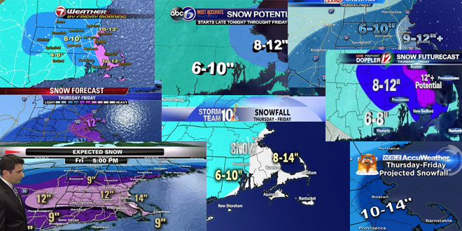
Back by popular demand it’s the TV Station snow forecast roundup! Here is a look at some of the social media updates from television stations in Southern New England about the big storm that will hit Thursday into Friday.
See the latest Right Weather accumulation map here.
Our latest snowfall estimates…heaviest at the Coastline, light and fluffy for all! #wbz pic.twitter.com/PZsJxGhUBH
— Terry Eliasen (@TerryWBZ) January 1, 2014
Happy New Year! Here's my latest snowfall forecast for Thu-Fri nor'easter- Ocean enhances amounts near coast #WCVB pic.twitter.com/tIKoZsrct9
— Cindy Fitzgibbon (@Met_CindyFitz) January 1, 2014
6"-10" in CT with 10"-16" for parts of N & E Mass & S NH. Worst of storm is Thursday night. #FirstAlertCT pic.twitter.com/7JDvSn8GXK
— Ryan Hanrahan (@ryanhanrahan) January 1, 2014
Weather ch says 12 to 18 in RI. They are all so different!
Fred why all stations say different totals ???
Samson Desrosiers, in this case, there is not much difference at all between the forecasts right now.
It’s seems that there is a very fine line between an all out blizzard and a more moderate storm, none of you have an easy job. I won’t be deciding whether or not to cancel classes at my karate school until tomorrow afternoon.
Michael Kiefer, many times there is a fine line. Last February, however, it was a slam dunk!
I feel so badly for my family and friends hearing this news. I moved to SC to get away from all this and I am so happy that I moved. I do have to admit that I DO miss my family and friends, but not the cold, ice and snow.
Fred, why blizzard warning for Long Island only and not RI and SE Mass? I ask this because of wind direction and storm total predictions. Seems like Long Island is further west of where the worst impacts will be.