The temperature did not make it to 35° in the Providence area for the seventh straight day. There are two more cold and dry days ahead before a storm makes a run at Southern New England on Thursday. Tuesday looks mostly sunny, but very cold for mid-January, with lows in the teens and highs in the 20s. There will be a 10 mph northwest breeze that makes it feel even colder.
The wind will relax Tuesday night as high pressure sits over New England. It will be a frigid night. The temperature may drop to near zero in the countryside, and into the single digits to low teens elsewhere. Wednesday looks like another chilly day, with plenty of sunshine and highs in the upper 20s to low 30s.
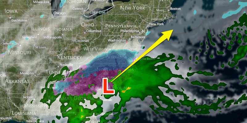
A winter storm will wreak havoc in the Southeastern United States on Wednesday before heading for the Mid-Atlantic and New England Wednesday night through Thursday. The storm may be paralyzing for parts of the Southeast due to combined snow and freezing rain.

The storm will likely intensify as it moves up the Eastern Seaboard. The track and intensity of the storm are critical in determining what the prevailing precipitation type will be. At this point, we are favoring a wintry mix or rain in coastal Southern New England, with a snow to rain in the I-95 corridor from Providence to Boston, and a better chance of a snow in NW RI and Worcester County. A change to rain is possible even in those areas. While we see those scenarios as most likely, there are other solutions still on the table. A track of an intense storm a bit farther offshore would be a major snow-maker in most of Southern New England. If it tracks closer to the coast, it become a cold rainstorm instead.
At this point, we expect snow or mixed precipitation to break out Thursday morning, with snow or rain likely in the afternoon and night. The storm may bring strong winds, especially near the coast. Gusts over 40 mph are likely at the coast of RI, near Buzzards Bay, and on Cape Cod and the islands. Stronger winds are possible if the storm strengthens and approaches the coast. We will continue to analyze the latest information and give updates on the storm potential on rightweather.com.
The weather looks fairly quiet on Valentine’s Day. It will be partly cloudy with highs in the 30s. A fast-moving Alberta Clipper may trigger snow showers Friday night into Saturday. It does not look like a major storm. A light snow accumulation is possible. Highs will be in the 30s on Saturday. Sunday should be dry with highs near 32°.


