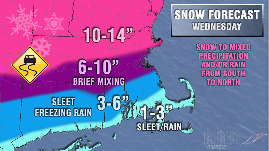
After seeing exclusively snow or rain for most storms in the past six weeks, Southeastern New England will be back to dealing with the familiar mixed bag of precipitation on Wednesday. A significant storm will bring a burst of snow during the morning commute that transitions to sleet, freezing rain, and rain during the day. It will remain mostly or all snow along and north of the Mass Pike, where 10″ or more of snow may accumulate.
- Video Update: Messy midweek storm
- TV station snow forecast roundup
- Download the RightWX app for your phone or tablet
- Right Weather Interactive Radar
The storm will begin from west to east before dawn on Wednesday. It will start in Western New England around 3 am, reach RI between 4-5 am, and ultimately get to Eastern MA between 4:30-5:30 am. The storm will come in fast and furious, with moderate to heavy snow possible within one hour of the first flake falling. Several hours of moderate to heavy precipitation are likely through Wednesday morning.

Above-freezing air a few thousand feet off the ground will move north through coastal Southern New England Wednesday morning. This warmer air will change snow to mixed precipitation, most likely sleet (ice pellets), from south to north during the morning. The sleet line may reach the coast as soon as 8 am, and could reach Providence by 10 am. It may make it as far north as the northern RI/MA border by noon. Snow will be piling up all morning inland. Snow totals in RI could range from as little as 1″ near the coast to as much as 10″ in the northern part of the state. The range in Massachusetts is likely to be even greater, with little or no snow on Nantucket and up to 14″ of snow in the northern part of the state.
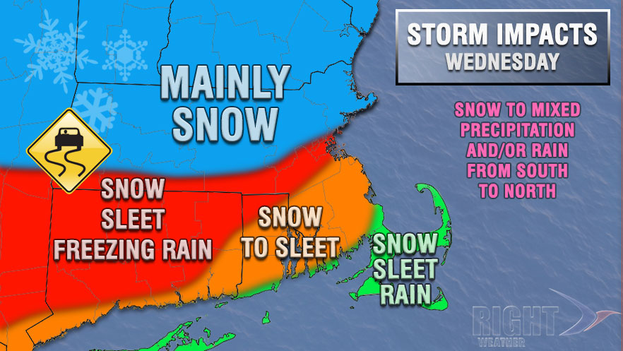
The coast will see a change from snow to sleet to rain on Wednesday, but inland locations, especially in interior CT, may see a few hours of freezing rain. 0.15-0.3″ of glaze is possible in interior CT and NW RI if the precipitation changes to freezing rain before noon. Freezing rain is when raindrops freeze on contact with a cold surface. It leads to an ice buildup on all cold surfaces, including trees and power lines.
The heaviest precipitation should pass by early in the afternoon, but lighter mixed precipitation, rain, and snow will continue through the afternoon into the evening. It will gradually turn colder Wednesday evening, and a coating of snow is possible as the storm exits around midnight. Some clearing is likely late Wednesday night, and the temperature will fall into the teens to low 20s by early Thursday morning. Watch out for icy spots Wednesday night and early Thursday.
The end of the workweek looks dry and cold. Thursday and Friday will both be partly cloudy with highs around 30°, and lows in the single digits to teens. Saturday should also be dry and cold. There is still the possibility of a storm late in the weekend, but it is not looking as likely as it did on Monday.


