
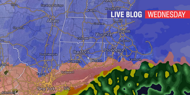
A fast and furious volatile winter storm is hitting New England on Wednesday, February 5, 2014. The storm will feature heavy snow, sleet, freezing rain, and rain in Southeastern New England. Check this page often for live blog updates on the current weather and forecast from Right Weather meteorologist Fred Campagna. Feel free to ask questions in the comment section near the bottom of the page.
- Download the FREE RightWX app for your Android or iOS device
- Check the Interactive Radar here
- Android users may need to visit this page to see the blog: http://goo.gl/hJG1bI
Thanks for checking out the Live Blog.
There will be no further updates to this blog.
Fred, at what time do you think we can plow/shovel in the Nk area without worries of anymore accumulation? Thanks
Hi Jay, I’m sorry that I do not have the time to promptly answer individual questions on the Live Blog. You may want to consider our Private Forecasting Service for your business. It will be light rain and mixed precip. this afternoon. A coating of snow is possible this evening.
Still all snow in Woonsocket at 9:10 AM
Fred, what time frame do you think it would be best to make the trek to the east bay to shovel out the parents?
Steve, anytime in the next 4-6 hours should be fine – or at least better than this morning. Flurries or snow showers are possible this evening, with little if any accumulation.
11:20AM, west glocester, nothing at all falling from sky. nothing. approx. 6.5 inches of snow, a little sleet on top.
Fred,
Moving on to Sunday. You said it appears they there will not be a large storm. I am debating taking
a weekend trip to visit family in NJ ( Atlantic City) but didn’t want to be traveling back Sunday with snow. Should I be good to go?
Light snow is possible from NJ to SNE on Sunday. Right now, it does not look like a big deal.