
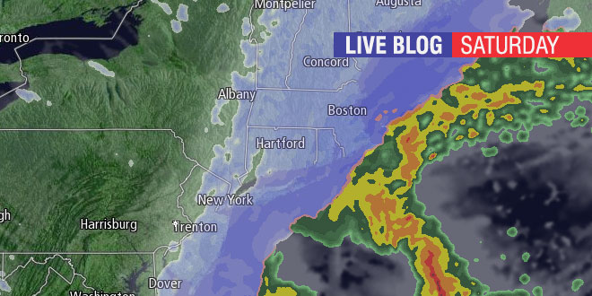
Snow is developing over Southern New England Saturday afternoon. A rapidly intensifying storm may bring blizzard conditions to Eastern MA, and will bring plowable snow to most of Southern New England. Right Weather Meteorologist Fred Campagna will have updates during the storm on this Live Blog. Feel free to ask questions in the comment section near the bottom of the page.
- Download the FREE RightWX app for your Android or iOS device
- Check the Interactive Radar here
- Android users may need to visit this page to see the blog: http://goo.gl/qGHhIe
Anyone else want to keep driving left until you hit that green stuff?
Fred, I am planning on traveling from Dighton to New Bedfod for my grandfathers 90th Bday dinner at 5:30pm with 4 wheel drive… how about 9pm drive back?? Under 45 on 195?
Keep up the awesome work!
Alex
Definitely looking at a VERY slow ride. Be careful.
Fred, when would you predict the strongest winds to occur in Charlestown? Any threat of damage? I’m not seeing a wind adv from nws
Realistically the heavy snow isn’t far from the eastern part of RI. Is there a chance we could see the heavy snow bands set up close to Conimicut Pt in Warwick?
Are you asking about the heavy snow bands that will be over Eastern MA? That is where the heaviest snow is likely. However, 6-8″ of snow in less than 12 hours means there will also be heavy snow in Warwick, just not as insane as what’s going to happen in Eastern MA.
Ok thank you Fred, yeah I was wondering if we could see up to 2-3″/hr sneak westward.
Are you going to do a live interactive stream?
Probably not. I’m fighting a head cold and do not feel like talking for an extended period of time. I’m happy to answer any questions you may have.
Thank you, Feel better and keep up the good work.
Hi Fred
Should we be preparing for power outages in the Tiverton area?
It can’t hurt. Heavy snow and strong winds can lead to isolated outages.
Measuring exactly 5 inches so far on the north side of Middletown.
8 inches in south tiverton, Westport line