
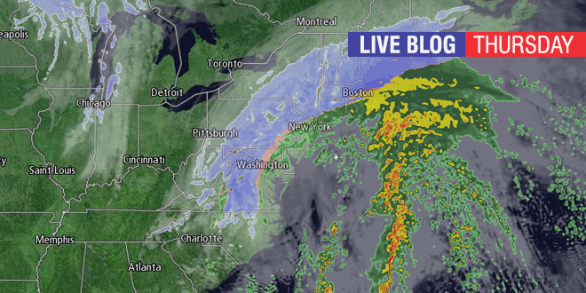
Snow, rain, and windy conditions will hit Southern New England on Thursday. Heavy accumulating snow is possible inland, and the timing of a change to rain is tricky in the I-95 corridor. Right Weather Meteorologist Fred Campagna will have updates throughout the day on this Live Blog. Feel free to ask questions in the comment section near the bottom of the page.
- Download the FREE RightWX app for your Android or iOS device
- Check the Interactive Radar here
- Android users may need to visit this page to see the blog: http://goo.gl/o2U1Jo
7 a.m. Woonsocket snow measured at 0.2 of an in.
Hello Fred,
How much of this accumulation do you expect to wash away? I’m wondering about the potential for street flooding for the evening commute (I’m in that Western Kent bullseye).
I’m trying to make an educated guess on my staff safty.around 7 and 8 pm will the rain freeze?
What area?
I was hoping to drive to NH today (about 1.5 hours north of Boston). Is there a window of opportunity? It looks pretty good here south of Providence, but I’m having a hard time getting a detailed prediction of weather north. I have kids with me and no 4WD, so I don’t want to do anything crazy.
You’d have to be getting on the road real soon. Otherwise, you’re looking at a burst of snow here, then moderate to heavy snow north of Boston from noon until at least 6 pm.
Riverside……33deg, Dew point 32deg, moderate wet heavy snow. Temperature trend is rising.
Great job Fred, everything going as you have stated all along!!!
Snowing like crazy here in Newport! Are we still expected to switch over soon? Wind seems to be picking up too!
The change to rain is coming. This burst of snow was expected. It’s taken a bit longer to arrive.
Props on the forecast Fred. Though the storm is far from over, I think you nailed the snowfall maps. Those were some of the biggest flakes I’ve seen in my life about an hour ago – usually those huge flakes don’t last as long as that burst did!
As usual, your forecast was right on target. I don’t even bother looking anywhere else for my weather forecast anymore. Thanks for the great work!
Changed to sleet in West Cranston but now back to snow.
Tough to get a good reading in the city, but just measured about 6.5″ in Woonsocket. Still snowing quite heavily, no sign of rain yet. Temperature still rising but starting to level off, 31 now.
At 2:20 pm 8″ of snow on the ground and snow is mixing with sleet in Chepachet!
Hi Fred- thanks for all the helpful information throughout this storm! Just wondering about the wind gusts. I live in East Greenwich near Greenwich Bay…could you tell me how strong you think the winds will gust in that area? I was a little worried about power outages. Thank you!
Winds will gust to 40-45 mph in the next 6-8 hours. Probably not strong enough for widespread outages.
Thank you Fred.
Fred- Great job as always with the storm today, I followed you pretty closely and for the past 3 days you had the general right idea on this one from the start and even the snow totals with the sharp shut-off line looked real good. So I am very curious on the Saturday storm potential, I have a number of things going on Saturday… any idea if the storm does get together and give us some moderate snow, what time do you think it would start? Bonus question if i am allowed, what is Tuesday afternoon and evening looking like? thanks…Brendan