AnalysisMobile

Live Blog: Tuesday, February 18, 2014

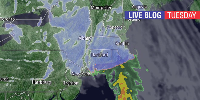
A quick-hitting burst of snow is in the forecast for Tuesday, February 18, 2014. Snow may be heavy for a couple of hours, and the best chance of accumulation is away from the coast. Right Weather Meteorologist Fred Campagna will have updates throughout the day on this Live Blog. Feel free to ask questions in the comment section near the bottom of the page.

Fred Campagna

President and Chief Meteorologist - Right Weather LLC AMS Certified Consulting Meteorologist #756 AMS Certified Broadcast Meteorologist #126

Related Articles

12 Comments

  1. Fred- seems like a lot of dry air is sucking up anything thats trying to fall over west glocester. the sun just came out briefly! I know this will not last, but it seems like this could be even more of a minor storm than originally thought. What do you think?

  2. Hi Fred – Earlier you were thinking that the snow in RI will be over by 5pm. Is it moving even faster now? I’m curious when the snow will end specifically in the Providence metro area. Thanks!

  3. Roads are horrendous in North Tiverton. Even the main roads are bad right now. Be safe, everyone!

    1. 4.5 was the final accumulation in western providence. It’s already compacted down about .6 inches since the changeover.

  4. Seems to be just about over in new bedford. How does it look heading to Westfield? I need to make that trek later on today.

Back to top button