
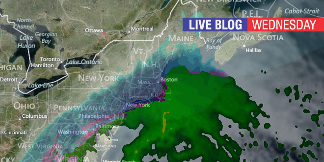
We continue tracking a major winter storm which will bring ice and snow to the Southeastern United States on Wednesday, and then snow and rain to Southern New England on Thursday. Right Weather Meteorologist Fred Campagna will have updates throughout the day on this Live Blog. Feel free to ask questions in the comment section near the bottom of the page.
- Download the FREE RightWX app for your Android or iOS device
- Check the Interactive Radar here
- Android users may need to visit this page to see the blog: http://goo.gl/suw0l9
Just curious on your thoughts for Friday morning. I have a flight out of Providence at 6:30 Friday morning and curious if you anticipate any delays or heavier snow that time in the morning.
Thanks!
Fred, You have been right on with your forecasts. So doubtful you will be wrong with this one. Couples inches of slop and then the next one misses. After that. Smooth sailing into spring
Is it just me or are meteorologists suffering from too much low to average certainty data? You guys have all these models which do certain things well and other things not so well. None of it seems to ever fully agree even as the storm hits. I know it’s computationally impossible to model the atmosphere fully, but it seems like I could be just as accurate to say, “It’s cloudy and cold so it might snow or it might now.”
Hey Fred, I am a RI native and have been following your forecasts for a while now and love the site! I live in central NH at the moment just on the edge of the White Mountains, I was wondering what you think we are going to pick up in terms of total accumulations, and the timing of the storm from start to finish? A lot of people will probably be wondering this because they will want to head North and take advantage of the amazing ski conditions.
Thanks,
Cam
While I would love to help out a fellow Plymouth Stater, I just don’t have the time to focus on the forecast for Northern New England. Safe to say, there should be a moderate to heavy snowfall that lasts through the night into early Friday. I’m sure the ski resorts are thrilled. You can get an hourly forecast here: http://rightweather.com/hourly-forecast/
What I find most interesting is how sharp the cutoff is between a heavy snowstorm and basically a rainstorm. I know this is a very difficult forecast with many moving parts and I also know an all snow scenario for SE NE is highly improbable, but I can definitely remember storms where the R/S line did not set up as far west as was forecast and things changed drastically mid-storm. Of course I’m hoping for more snow (I’m not a professional so I’m allowed to wish cast hahaha) but it seems like such a close call, what would it take to happen for us to get more snow in RI (and I fully understand that is NOT your forecast)?
Hey Fred, would an earlier arrival of the precipitation lead to more snow possibly? Great work as always. Harrison.
Hi Fred,
Thanks for all the great blog posts. We live in Bristol county, MA and we still have a lot of snow on our roof, will the temps be warm enough near the coast to help melt it off or can we expect more of a sponge effect with all the predicted rain?
Thanks,
Terri