Since the Winter Olympics are right around the corner, we thought we’d share this ski jump as an analogy to how difficult the snow forecast is for Southeastern New England Tuesday night into Wednesday.
Ok, maybe that’s a little tougher than the forecast, but the point is this event could bring anywhere from a quick change to sleet/rain to a foot of wet, heavy snow in RI and SE MA. We think that reality lies between those two extremes, with several inches of snow possible before a change to mixed precipitation and/or rain from south to north.
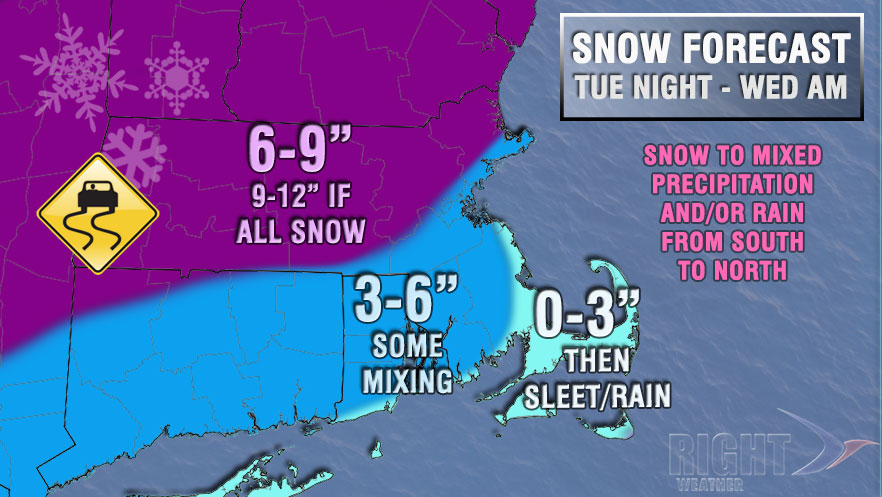
The best chance of seeing more than 6″ of snow is away from the coast, specifically north of the MA Pike. The computer model trend yesterday was for a colder scenario, but that seems to have stabilized today with a track that is too close to the coast for all snow, especially south and east of I-95. The timing is after midnight through most of Wednesday, with the best chance of accumulating snow before 9 am Wednesday.
Things to watch
Storm Track – Obviously, this is key. A track closer to the coast brings in mild air and changes snow to sleet and sleet to rain. If it’s offshore, there is a better chance of snow. Incidentally, the milder air with this storm is not necessarily at the surface. The snow spoiler may occur with above-freezing air about 5,000 feet above the surface.
Timing – Right now, the timing is not great for the Wednesday morning commute. Even the warmer models have mixed precipitation during the morning commute. The colder solutions have either snow or mixed precipitation. An earlier start time could be good or bad. If the storm trends warmer, than an earlier start would likely have the precipitation changing to rain by the AM commute. If the storm is cold, then that just allows more time for snow to accumulate. The timing would have to shift considerably to not have moderate to heavy precipitation (snow, sleet, or rain) during the AM commute.
“Front-end thump” – Sometimes, these storm systems bring in the heaviest precipitation in the first few hours. If that happens with this storm, there is a better chance of getting several inches of snow before the mild air can arrive.
The Bottom Line
This is the best time of year to have a storm that tracks this close to the coast bring several inches of accumulating snow. The ocean temperature is in the low to mid 30s, and the storm may try to redevelop a bit closer to the Gulf Stream (warmer water), which would take it a bit farther offshore. At this point, with energy for the storm just reaching Western North America, we think there is a lot of wiggle room in this forecast. However, we do not expect an exclusively snow event in the I-95 corridor.


